Precision agriculture merges the new technologies borne of the information age with a mature agricultural industry. It is an integrated crop management system that attempts to match the kind and amount of inputs with the actual crop needs for small areas within a farm field. This goal is not new, but new technologies now available allow the concept of precision agriculture to be realized in a practical production setting.
Precision agriculture often has been defined by the technologies that enable it and is often referred to as GPS (Global Positioning System) agriculture or variable-rate farming. As important as the devices are, it only takes a little reflection to realize that information is the key ingredient for precise farming. Managers who effectively use information earn higher returns than those who don't.
Precision farming distinguishes itself from traditional agriculture by its level of management. Instead of managing whole fields as a single unit, management is customized for small areas within fields. This increased level of management emphasizes the need for sound agronomic practices. Before considering the jump to precision agriculture management, a good farm management system must already be in place.
Precision agriculture is a systems approach to farming. To be viable, both economic and environmental benefits must be considered, as well as the practical questions of field-level management and the needed alliances to provide the infrastructure for technologies. Figure 1 represents some of the important considerations in a precision agriculture system. The issues surrounding precision agriculture include perceived benefits and also barriers to widespread adoption of precision agriculture management.
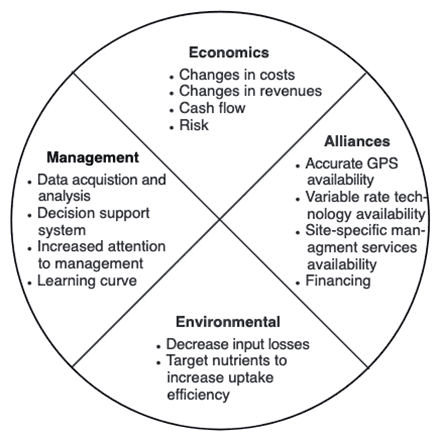 Figure 1
Issues affecting adoption of precision agriculture management.
Management
- Data acquisition and analysis
- Decision support system
- Increased attention to management
- Learning curve
Economics
- Changes in costs
- Changes in revenues
- Cash flow
- Risk
Alliances
- Accurate GPS availability
- Variable rate technology availability
- Site-specific management services availability
- Financing
Environmental
- Decrease input losses
- Target nutrients to increase uptake efficiency
The need for precision agriculture
Farmers usually are aware that their fields have variable yields across the landscape. These variations can be traced to management practices, soil properties and/or environmental characteristics. Soil characteristics that affect yields include texture, structure, moisture, organic matter, nutrient status and landscape position. Environmental characteristics include weather, weeds, insects and disease.
The aerial photo in Figure 2 illustrates that in some fields, within-field variability can be substantial. In this field, the best crop growth was near waterways and level areas of the field. Sideslopes where erosion depleted topsoil showed moisture stress and reduced plant stands. In Missouri, the variation in yield levels for corn and soybean is typically 2 to 1.
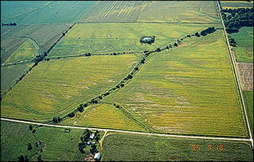 Figure 2
Aerial view of a central Missouri field.
Seeing this magnitude of variation prompts most farmers to ask how the problem that is causing the low yields can be fixed. There is no economically feasible method of "fixing" the depleted topsoil areas in this field, so the management challenge is to optimally manage the areas within the field that have different production capacities. This does not necessarily mean having the same yield level in all areas of the field.
A farmer's mental information database about how to treat different areas in a field required years of observation and implementation through trial-and-error. Today, that level of knowledge of field conditions is difficult to maintain because of the larger farm sizes and changes in areas farmed due to annual shifts in leasing arrangements. Precision agriculture offers the potential to automate and simplify the collection and analysis of information. It allows management decisions to be made and quickly implemented on small areas within larger fields.
Tools of precision agriculture
In order to gather and use information effectively, it is important for anyone considering precision farming to be familiar with the technological tools available. These tools include hardware, software and recommended practices.
Global Positioning System (GPS) receivers
Global Positioning System satellites broadcast signals that allow GPS receivers to calculate their position. This information is provided in real time, meaning that continuous position information is provided while in motion. Having precise location information at any time allows soil and crop measurements to be mapped. GPS receivers, either carried to the field or mounted on implements allow users to return to specific locations to sample or treat those areas.
Uncorrected GPS signals have an accuracy of about 300 feet. To be useful in agriculture, the uncorrected GPS signals must be compared to a land-based or satellite-based signal that provides a position correction called a differential correction. The corrected position accuracy is typically 63-10 feet. In Missouri, the Coast Guard provides differential correction beacons that are available to most areas free of charge. When purchasing a GPS receiver, the type of differential correction and its coverage relative to use area should be considered.
Yield monitoring and mapping
Grain yield monitors continuously measure and record the flow of grain in the clean-grain elevator of a combine. When linked with a GPS receiver, yield monitors can provide data necessary for yield maps. Yield measurements are essential for making sound management decisions. However, soil, landscape and other environmental factors should also be weighed when interpreting a yield map. Used properly, yield information provides important feedback in determining the effects of managed inputs such as fertilizer, lime, seed, pesticides and cultural practices including tillage and irrigation.
Yield measurements from a single year may be heavily influenced by weather. Examining yield information records from several years and including data from extreme weather years helps in determining if the observed yield level is due to management or is climate-induced.
Grid soil sampling and variable-rate fertilizer (VRT) application
In Missouri, the recommended soil sampling procedure is to take samples from portions of fields that are no more than 20 acres in area. Soil cores taken from random locations in the sampling area are combined and sent to a laboratory to be tested. Crop advisors make fertilizer application recommendations from the soil test information for the 20-acre area. Grid soil sampling uses the same principles of soil sampling but increases the intensity of sampling. For example, a 20-acre sampling area would have 10 samples using a 2-acre grid sampling system (samples are spaced 300 feet from each other) compared to one sample in the traditional recommendations. Soil samples collected in a systematic grid also have location information that allows the data to be mapped. The goal of grid soil sampling is a map of nutrient needs, called an application map. Grid soil samples are analyzed in the laboratory, and an interpretation of crop nutrient needs is made for each soil sample. Then the fertilizer application map is plotted using the entire set of soil samples. The application map is loaded into a computer mounted on a variable-rate fertilizer spreader. The computer uses the application map and a GPS receiver to direct a product-delivery controller that changes the amount and/or kind of fertilizer product, according to the application map.
Remote sensing
Remote sensing is collection of data from a distance. Data sensors can simply be hand-held devices, mounted on aircraft or satellite-based. Remotely-sensed data provide a tool for evaluating crop health. Plant stress related to moisture, nutrients, compaction, crop diseases and other plant health concerns are often easily detected in overhead images. Electronic cameras can also record near-infrared images that are highly correlated with healthy plant tissue. New image sensors with high spectral resolution are increasing the information collected from satellites.
Remote sensing can reveal in-season variability that affects crop yield, and can be timely enough to make management decisions that improve profitability for the current crop. Remotely-sensed images can help determine the location and extent of crop stress. Analysis of such images used in tandem with scouting can help determine the cause of certain components of crop stress. The images can then be used to develop and implement a spot treatment plan that optimizes the use of agricultural chemicals.
Crop scouting
In-season observations of crop conditions may include:
- Weed patches (weed type and intensity)
- Insect or fungal infestation (species and intensity)
- Crop tissue nutrient status
- Flooded and eroded areas
Using a GPS receiver on an all-terrain vehicle or in a backpack, a location can be associated with observations, making it easier to return to the same location for treatment. These observations also can be helpful later when explaining variations in yield maps.
Geographic information systems (GIS)
Geographic information systems (GIS) are computer hardware and software that use feature attributes and location data to produce maps. An important function of an agricultural GIS is to store layers of information, such as yields, soil survey maps, remotely sensed data, crop scouting reports and soil nutrient levels. Geographically referenced data can be displayed in the GIS, adding a visual perspective for interpretation.
In addition to data storage and display, the GIS can be used to evaluate present and alternative management by combining and manipulating data layers to produce an analysis of management scenarios.
Information management
The adoption of precision agriculture requires the joint development of management skills and pertinent information databases. Effectively using information requires a farmer to have a clear idea of the business' objectives and of the crucial information necessary to make decisions. Effective information management requires more than record-keeping analysis tools or a GIS. It requires an entrepreneurial attitude toward education and experimentation.
Identifying a precision agriculture service provider
Farmers should consider the availability of custom services when making decisions about adopting site-specific crop management. Agricultural service providers may offer a variety of precision agriculture services to farmers. By distributing capital costs for specialized equipment over more land and by using the skills of precision agriculture specialists, custom services can decrease the cost and increase the efficiency of precision agriculture activities.
The most common custom services that precision agriculture service providers offer are intensive soil sampling, mapping and variable rate applications of fertilizer and lime. Equipment required for these operations include a vehicle equipped with a GPS receiver and a field computer for soil sampling, a computer with mapping software and a variable-rate applicator for fertilizers and lime. Purchasing this equipment and learning the necessary skills is a significant up-front cost that can be prohibitive for many farmers.
Agricultural service providers must identify a group of committed customers to justify purchasing the equipment and allocating human resources to offer these services. Once a service provider is established, precision agriculture activities in that region tend to center around the service providers. For this reason, adopters of precision farming practices often are found in clusters surrounding the service provider.
A management example
Every farm presents a unique management puzzle. Not all the tools described above will help determine the causes of variability in a field, and it would be cost-prohibitive to implement all of them immediately. An incremental approach is a wiser strategy, using one or two of the tools at a time and carefully evaluating the results.
The examples shown here are from a central Missouri farm. Figure 3 shows yields for three years of crop production, soybean in 1992 and 1994, and corn in 1993. For comparison, the yields were adjusted to relative yields, that is, the actual yield was expressed as a fraction of the maximum yield within that year. Notice the relative yield patterns for the three years changed from year to year, and between the different crops. The average yield map revealed two areas of high yield. One area was in the north-central part of the field, and the other extended from the western to eastern boundary in the southern one-third of the field. At this point, it is clear there is a persistent factor or factors affecting yield but more information is needed to determine those factors.
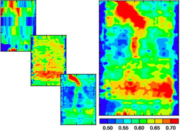 Figure 3
Grain yields for three years (left, top to bottom: 1992, 1993, 1994) and average three-year yields (right) as a fraction of maximum yield within each year for a central Missouri field. Blue = 0.50 x maximum yield; red = 0.70 x maximum yield.
In Figure 4 soil test phosphorus and potassium maps are shown alongside a soil pH map. Phosphorus and potassium maps are similar, with low soil test values in the northern one-third of the field. Soil pH values were higher (near neutral) in the southern one-third of the field and along the far southern edge of the field. The well-defined boundary of the high pH area and the fact that it appears to follow the direction of field management suggests this is a consequence of management rather than natural soil variability.
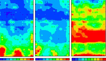 Figure 4
Soil test phosphorus, potassium and pH for a central Missouri farm.
Strong evidence that management resulted in the pH patterns is given in Figure 5 where a photograph taken in 1962 showed that the field, now managed as a single unit, was previously broken into three fields that were managed separately. Two farmsteads were located in the southwestern corner and south-central edge of the field (notice the high phosphorus concentration in the areas near the previous farmsteads), and the southern part of the field was in pasture. The previous landowner later confirmed that lime was applied to the three fields separately. A reasonable explanation for the high pH area is that more lime was applied on the field adjacent to the farmstead/pasture area than was applied to the fields farther north. The higher pH along the far southern edge was likely caused by limestone dust blown from the gravel road that appears in the 1962 aerial photograph. An obvious corrective measure is to lime the other parts of the field to raise the pH of those areas.
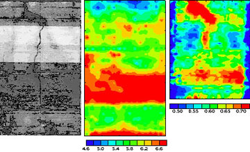 Figure 5
Aerial photograph, soil pH and 3-year average grain yields for central Missouri farm.
The higher grain yields that appear spatially related to the high pH area may be caused by favorable soil conditions related to pH. However, correlation between yield and a soil parameter is not certain proof that pH is the cause of higher yields. Past management of this portion of the field may have been the more important factor resulting in higher yields. Certainly, additional factors beside soil pH affected yield, because the area of high yield is substantially smaller than the area of high pH.
The pH map does not spatially correspond to the area of high yield extending from the northwestern corner of the map to the north-central portion. Unlike the pH-affected area, this feature does appear to be a natural soil-related feature. It matches well with the drainage channel that is visible in the aerial photograph. Understanding this yield variability pattern requires some knowledge of this central Missouri farm soil. Soils in the area are classified generally as claypan soils. A claypan soil has an abrupt soil textural change (an increase in clay) between the surface soil and the claypan, a layer that restricts water movement and root growth. In years when water limits plant growth there is a close relationship between the depth of the topsoil overlaying the claypan and yields.
In Figure 6 a map of topsoil depth is shown alongside the 3-year average yield map. The topsoil depth information was collected with a mobile sensing unit linked to a GPS receiver. The sensing unit actually measures the ability of the soil to conduct electricity, and clays conduct electricity better than soils that have less clay. So, claypan soils that have shallow topsoils conduct the electricity better than soils with deep topsoils.
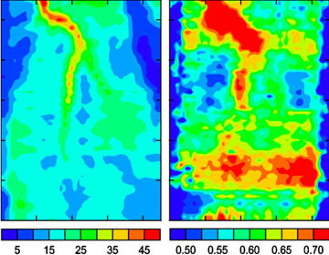 Figure 6
Depth of topsoil and 3-year average yield for a central Missouri Farm.
Figure 6 shows the area of deepest topsoil is along the drainage channel and this area is clearly the high-yield portion of the field. Together the maps suggest that when the depth of topsoil is mapped, the soil's productive capacity related to soil water relationships can be predicted for different areas of the field. This has implications for nutrient application, especially nitrogen fertilizer. In Missouri, nitrogen is applied in accordance to predicted plant needs by estimating the yield goal for a field. Because yield goal (potential productivity) is closely related to topsoil depth, a map of topsoil depth can be used to guide the variable-rate application of nitrogen.
Summary
Precision agriculture gives farmers the ability to more effectively use crop inputs including fertilizers, pesticides, tillage and irrigation water. More effective use of inputs means greater crop yield and(or) quality, without polluting the environment. However, it has proven difficult to determine the cost benefits of precision agriculture management. At present, many of the technologies used are in their infancy, and pricing of equipment and services is hard to pin down. This can make our current economic statements about a particular technology dated.
Precision agriculture can address both economic and environmental issues that surround production agriculture today. It is clear that many farmers are at a sufficient level of management that they can benefit from precision management. Questions remain about cost-effectiveness and the most effective ways to use the technological tools we now have, but the concept of "doing the right thing in the right place at the right time" has a strong intuitive appeal. Ultimately, the success of precision agriculture depends largely on how well and how quickly the knowledge needed to guide the new technologies can be found.
Acknowledgements
Funding for this Guide sheet series was provided by the U.S. Environmental Protection Agency and administered by the Missouri Department of Natural Resources. Assistance was also provided by the U.S. Department of Agriculture-Agricultural Research Service Cropping Systems and Water Quality Unit and the Missouri Precision Agriculture Center.