MoRAP develops, analyzes, and delivers geospatial data for environmental resource planning and management. Our staff has worked on a wide variety of projects across the Midwestern and Southern US.
Missouri Soil and Atmospheric Monitoring Plan and Soil Maps Development

We are partnering with the Missouri Climate Center and Missouri Department of Natural Resources to develop a soil moisture monitoring plan for the state of Missouri and to develop a modeling/computing framework that generates daily statewide soil moisture maps to be used in the forthcoming Missouri Hydrology Information Center (MoHIC) dashboard.
Mapping Tree Planting Opportunities in the St. Louis Region
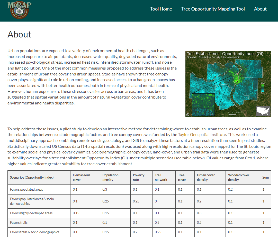
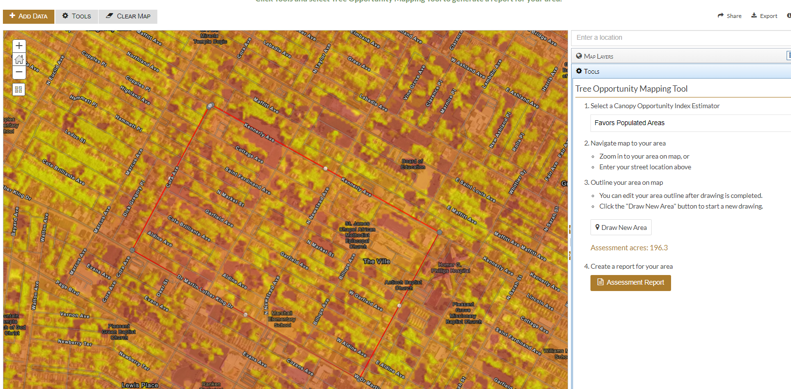
We partnered with researchers at Saint Louis University (Taylor Geospatial Institute) to examine relationships between tree cover and sociodemographics, and to use suitability modeling to establish opportunity indices for tree planting in the St. Louis region. This work was deployed in a web mapping tool, which enables users to interactively draw areas of interest and generate suitability and demographic reports to facilitate urban tree canopy planning efforts.
Enhancing Conservation Management at Prairie Fork Creek Conservation Area through the use of Precision Remote Sensing and Integrated Modeling
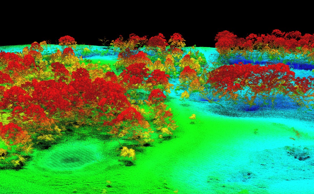
We are using UAV-based LiDAR and multispectral imagery, fused with high-resolution satellite data to produce high quality land-cover, vegetation, and terrain models for the Prairie Fork Conservation Area. Additionally, we are leveraging these data to advance invasive species mapping approaches.
Ecological Mapping Systems of Arkansas
A Habitat Classification Tool to Facilitate Conservation Prioritization and Action for Species of Greatest Conservation Need
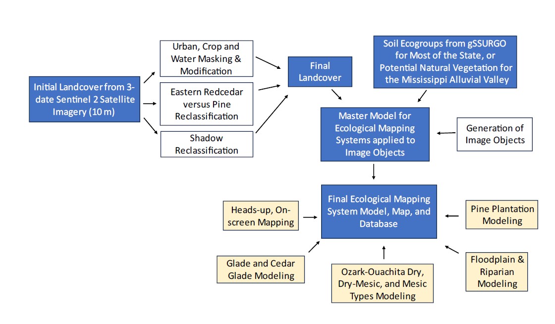
MoRAP worked with state leaders from several agencies in Arkansas, led by the Arkansas Fish and Game Commission, to initiate this project, with the aims of facilitating conservation prioritization and actions for habitats and species of greatest conservation need.
Key elements of the Arkansas EMS datasets include (1) use of 1704 georeferenced ground data points to drive the outcomes, (2) use of multiple dates of European Space Agency Sentinel 2 satellite imagery which allowed for mapping at 10 m resolution, (3) use of local, state-based ecological expertise to define the location and geophysical setting for EMS mapping targets, and (4) use of a number of ancillary datasets to improve landcover mapping accuracy and to increase the number of EMS types mapped.
A total of 123 EMS types were mapped in Arkansas, including common cultural and ruderal landcover and vegetation such as pine plantation and developed types. Ozark-Ouachita Dry-Mesic Forest covered the most area, 17.51% of the state. Row crops covered 17.16%. Twenty-five pine or pine plantation EMS types covered 19.73% of the state, with Ozark-Ouachita pine woodland or mature pine plantation covering 6.15%.
Improving Texas Ecological Mapping Systems for Southern Texas Coastal Counties
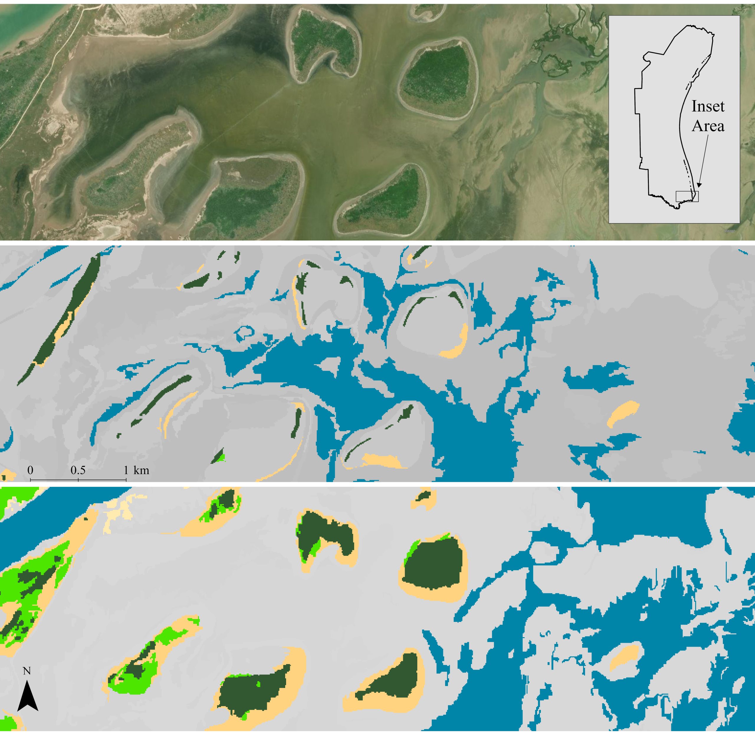
MoRAP mapped 22 Enduring Feature (EF) types and 66 Ecological Mapping Systems (EMS) for eight coastal counties in south Texas, from Refugio and Aransas County south to the Mexican border, using a multi-faceted approach that included Sentinel-2 satellite imagery, LiDAR data, and geophysical data.
Ecological Systems Mapping for Nebraska and Kansas

MoRAP worked with partners in Nebraska and Kansas to produce a uniform, consistent, fine-resolution Ecological Classification System (ECS) dataset for Nebraska and Kansas. The goal is to have a hierarchical landcover that accurately maps terrestrial upland habitats to the ecological systems level (National Vegetation Classification System-NVCS Alliance level 2016) and wetlands to National Wetlands Inventory (USFWS 2016) class level, while incorporating the Terrestrial Ecological Systems and Natural Communities of Nebraska (Rolfsmeier and Steinauer 2010) as well as possible.
Mapping at this level provides critical information for conservation planning, project review, development of species distribution models, and development of Decision Support Tools to guide on-the-ground conservation delivery. Mapping at this level is also consistent with the landcover datasets that have been developed for Texas (Diamond and Elliott 2010) and Oklahoma (Diamond and Elliott 2015), in partnership with the Great Plains LCC. Consistent landcover data across the Great Plains and ensures that accurate and applicable landscape conservation design products can be developed to guide future actions of our partnerships.
New Mexico Riparian and Wetland Habitat Mapping
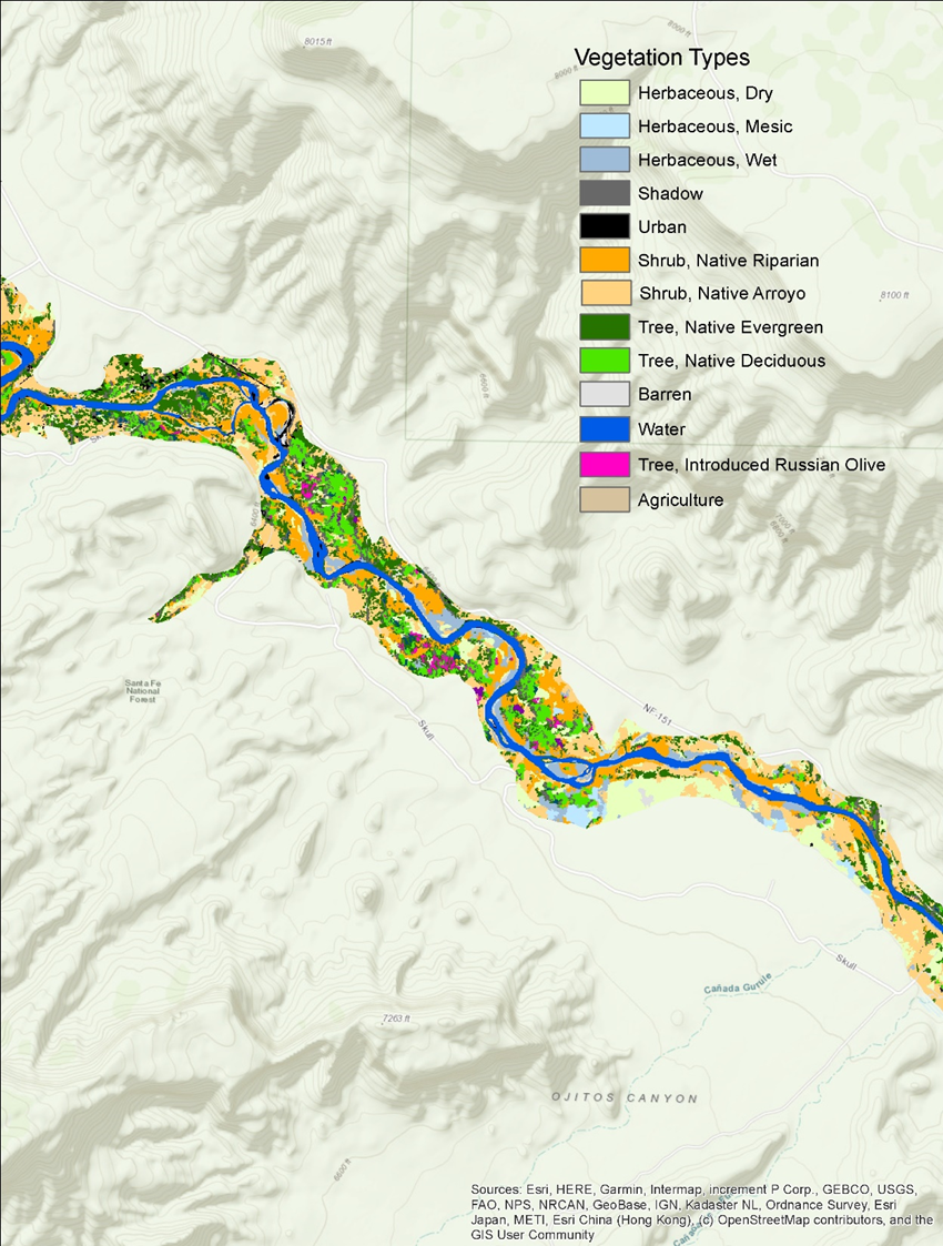
Riparian and wetland habitats are vitally important to New Mexico’s fish and wildlife, yet they are among the rarest habitats in the state. Despite their small area, most of New Mexico’s vertebrate species depend on riparian areas for food, water, cover, and/or migration routes. These habitats are also among the most threatened, as they are fairly sensitive to disturbance and change.
MoRAP worked with partners in New Mexico to develop statewide riparian and wetland maps using a combination of high-resolution imagery, machine learning, and environmental modeling approaches. These maps delineate the composition, cover, and structure of riparian and wetland vegetation at a fine scale across New Mexico, including the location and extent of invasive species such as salt cedar. They also provide a baseline for tracking tamarisk leaf beetle impacts and their severity, indicate where restoration if urgently needed to prevent habitat loss, and support fish and wildlife surveys and monitoring. Additionally, the maps include ecological descriptions to support wildlife management and restoration across the full range of riparian and wetland habitat conditions in the state.
Updating Fire Fuel Models for Texas
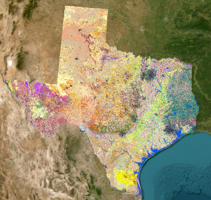
MoRAP worked with the Texas A&M Forest Service (TFS) to create the input datasets necessary to update the surface and canopy fuels for the Texas Wildfire Risk Assessment using the latest technology and methods. These datasets included land-cover, ecological systems models, and percentage canopy cover at 10 meters across the state of Texas. The purpose of the Texas Wildfire Risk Assessment is to provide wildfire risk information and create awareness about wildfire issues across the state.
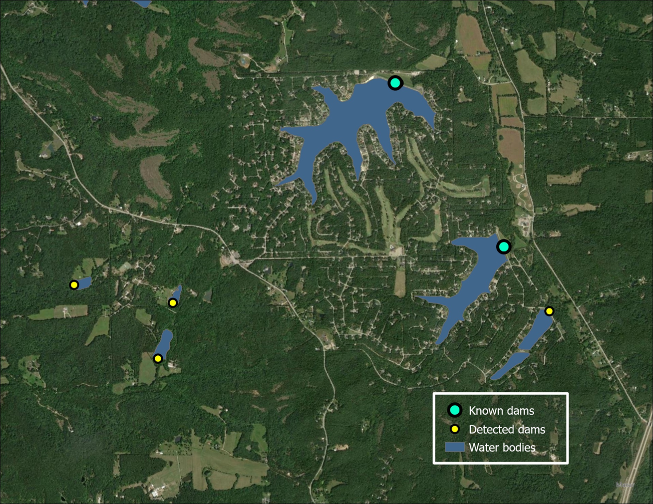
Update the National Inventory of Dams for Missouri
MoRAP worked in partnership with the Missouri Department of Natural Resources (MDNR) to updaMissouri National Inventory of Dams mapping and analysiste the National Inventory of Dams (NID) for numerous Missouri counties. Results help provide information that will be used to estimate the cost and time required to complete the NID for the entire state, as well as to identify unregulated dams using semi-automated approaches.