-
Image
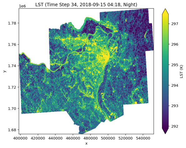 MU Extension researchers are using NASA data to map land surface temperatures. This will help transportation planners in the St. Louis area identify areas where green infrastructure could reduce extreme heat.
 -
Image
 MU Extension researchers are using NASA data to map land surface temperatures. This will help transportation planners in the St. Louis area identify areas where green infrastructure could reduce extreme heat.
ST. LOUIS, Mo. – University of Missouri Extension specialists are using NASA satellite data to help transportation planners identify areas along highways in the St. Louis metropolitan region where green infrastructure could reduce extreme heat and improve public health.
Michael Sunde, MU Extension state natural resource specialist, is working with the East-West Gateway Council of Governments on an initiative that analyzes data from the International Space Station, which provides high-resolution imagery of land surface temperatures. These geospatial insights help planners design green spaces near transit corridors to improve public health and safety, enhance roadway aesthetics and reduce long-term maintenance costs, Sunde says.
“Green infrastructure plays a vital role in cooling urban environments, filtering stormwater and supporting biodiversity,” he says. “By integrating science-based data from multiple agencies, we can make better-informed transportation planning decisions.”
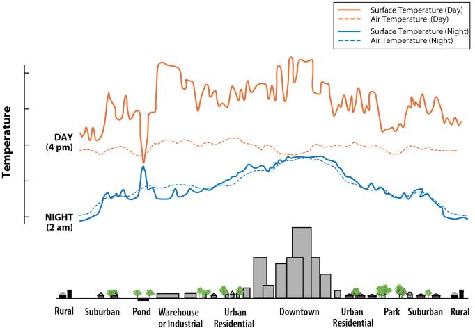
Examples of green infrastructure
Green infrastructure refers to natural and engineered systems that manage water and heat while supporting ecological health. Common examples include:
- Urban tree canopies and vegetated buffers along roads.
- Rain gardens and bioswales to manage stormwater.
- Green roofs and living near transit hubs.
- Permeable pavements that reduce runoff and heat absorption.
- Native plant landscaping to support pollinators and wildlife.
- Constructed wetlands for water filtration and habitat creation.
These features not only reduce surface temperatures but also improve air quality, reduce flooding and create more livable urban environments, Sunde says.
The Ecological Initiative compiles and shares environmental data with metropolitan planning organizations, state departments of transportation and local governments to support ecologically responsible infrastructure development.
Before NASA’s data became available, planners relied on manually installed heat sensors that measured air temperature. NASA now provides more accurate land surface temperature readings, enabling better modeling and planning for heat mitigation, he says.
Sunde leads MU Extension’s Missouri Resource Assessment Partnership (MoRAP), which coordinates the development and delivery of geospatial and remote-sensing data in collaboration with MU’s School of Natural Resources. MoRAP provided mapping data for this project.
Learn more about the ecological approach to infrastructure development at the East-West Gateway Council of Governments.