The Mississippi River Alluvial Valley is called the Delta region. The Delta includes parts of Missouri, Tennessee, Arkansas, Mississippi and Louisiana. This report focuses on the Upper Delta in Southeast Missouri. It is one of the most fertile places for growing crops in the United States (Figure 1). The high crop productivity is due to the soils, climate and abundant ground water for irrigation. Delta soils were formed by alluvial sediments from the Mississippi and Ohio rivers and smaller rivers from the Ozark Highlands. Temperatures in the growing season are warm enough for producing cotton and rice, but also suited for producing high yields of corn and soybeans. Farmers often apply water with furrow and center pivot irrigation systems during periods of low rainfall.
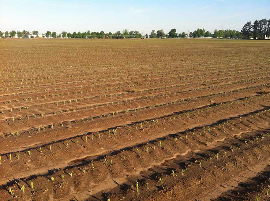
Figure 1. Most fields in the Delta region are 80 or more acres in size and have been mechanically graded to about 0.1% slope for water drainage. The slope on a given field usually depends on what required the least amount of soil movement (i.e., lowest cost).
This report describes the different kinds of soils and their locations in the Delta, explains how they were formed, and provides an evaluation of their potential for production and adaptation to different crops. The Delta is an alluvial valley of recent geological age. Soils are usually in the early stages of weathering with slight to moderate horizon development. When alluvial material was deposited, sediments often varied in texture due to shifts in stream channels, sometimes with clay over sand and vice versa (Figure 2).
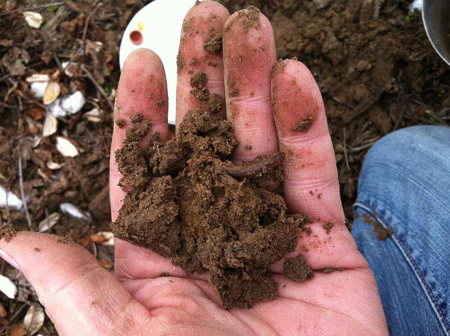
Figure 2. Delta soils were formed from river sediment deposits. They have slight to moderate profile layer development because of their young geologic age.
Farmers should remember that the present prosperity of the region was preceded by the toil and struggle of the pioneers who cleared the land and constructed the first drainage ditches. There were many failures in capital investment for reclamation before the land became productive. The physical, agricultural and cultural development of the Delta forms a special chapter in the history of Missouri.
A distinct agricultural region
The Delta Region in Southeast Missouri is the northern end of the Mississippi River Alluvial Valley. It includes all or part of 11 counties: Bollinger, Butler, Cape Girardeau, Dunklin, Mississippi, New Madrid, Pemiscot, Ripley, Scott, Stoddard and Wayne. The total area is about 3,900 square miles, or 2.5 million acres. The physical boundaries are defined on the east by the Mississippi River and on the west by the Ozark Escarpment. At the Escarpment, an abrupt drop in elevation occurs where the hills of the Ozarks meet the level alluvial plain of the Delta.
Southeast Missouri was once called the “Big Swamp” (Figure 3). The town of New Madrid was founded by Spain in 1778. Few people lived in the region because the land was covered in water most of the year. In 1803, the Delta became part of the United States when it was acquired from France as part of the Louisiana Purchase. Earthquakes in 1811 and 1812 caused stream banks to collapse, which further reduced water drainage. The region had many sand sloughs, river swamps and small lakes. Traveling in the region was difficult for people and mosquitoes were vectors for spreading disease. Lumbering was a major industry from 1890 to 1930. In 1840 there was an influx of German immigrants, but the greatest increase in population has occurred since 1910. The transformation of the Delta into farmland increased after the Little River Drainage System was constructed and the area of cultivated land increased from an estimated 600,000 acres in 1900, to more than 1.8 million acres in 1960.
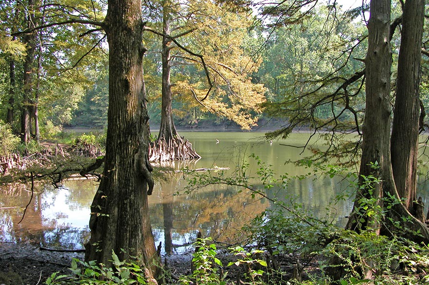
Figure 3. The Delta land was called the Great Swamp because the land was covered in water most of the year. Photo is a natural oxbow lake surrounded by cypress forest in the Wolf Bayou Conservation Area near Hayti, Missouri. The lake is an old bend in the Mississippi River, which changed course and no longer flows through the loop.
Many changes have occurred over the past 175 years. The early economy was based on harvesting timber, and the lumber was moved to outside markets by railroads. As the number of large trees declined, row crop farming became important. Over the following decades, agriculture transitioned from sharecrop farming to commercial operations. The number of farms decreased while farm size increased. Tractors replaced mules, and field equipment increased in size. Herbicides replaced laborers chopping weeds. To effectively manage more land area, farmers began using crop consultants and scouts to monitor fields for pests. The economy of the region is still based on agriculture, which is significantly affected by soils. For example, cotton, corn and soybeans grow best on well-drained soils. Rice is generally flood irrigated and needs soils with enough clay to retain water.
Known by several names
Most farmers and the general public call the region “the Delta.” Soil scientists and geologists often prefer “Lowlands” instead of Delta for the region name. In this publication, Lowlands will be used for subregions.
Deltas are the area near the mouth of rivers with active areas of sedimentation. The Mississippi River Delta does not exactly fit the definition. It is a vast area extending southward 600 miles from Cape Girardeau, Missouri. Geologists have hypothesized that in prehistoric times, stress in the North American continental plate caused a rift in the upper crust. This created a large trough extending from south of Cape Girardeau to the Gulf of Mexico. Over time, glacial periods produced enormous amounts of outwash and the sediment that filled the trough and formed lowlands. The thickness of delta soils averages more than 125 feet. The deep substratum material consists largely of beds of sand and gravel and is coarser in texture than the upper surface deposits.
Shifts of rivers
Shifts of the Mississippi and Ohio rivers altered the land surface to form subareas of the Delta (Figure 4). The names assigned to lowland areas were developed by geologists and geographers in 1958. The six subareas listed below are characterized by different soil and drainage conditions.
- Upland-Crowley’s Ridge and Scott County Hills
- Western Lowland
- Advance Lowland
- Kennett and Sikeston Ridges
- Morehouse Lowland-Essex terrace and Little River overflow
- Eastern Lowland-Charleston terrace and Mississippi meander belt
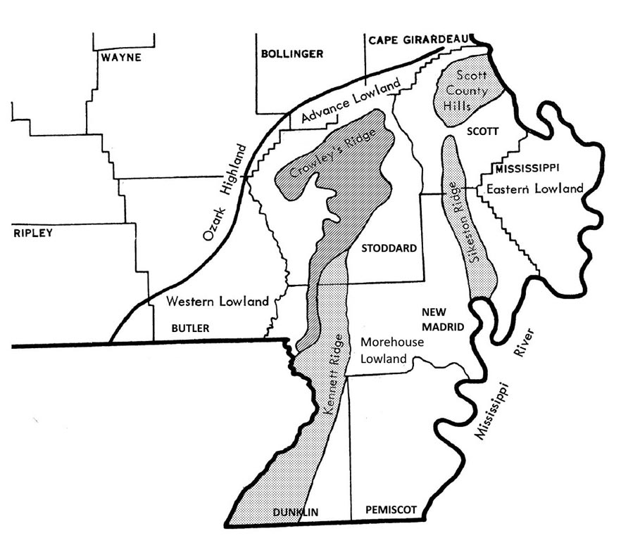
Figure 4. Map of lowlands, ridges and hills in Southeast Missouri Delta Region (Data source: U.S. Geological Survey).
The Mississippi River originally turned west at Cape Girardeau and occupied the Western Lowland between Crowley’s Ridge and the Ozark Highlands. The Ozark Escarpment was the west bank of the Mississippi River. The Ohio River occupied the Eastern Lowland south of Scott County Hills and flowed south along the eastern edge of Crowley’s Ridge. At that time, the Scott County Hills and Crowley’s Ridge were a continuous upland and formed the divide between the Mississippi and Ohio rivers. The junction of the two large rivers was near Helena, Arkansas.
Later, the Mississippi River changed course and cut through Crowley’s Ridge, forming a large gap in the upland soils between Bell City and Oran, Missouri. At the time, the Kennett Ridge and Sikeston Ridge were connected. Then, the Mississippi River shifted again to occupy Thebes Gap, a gorge north of Commerce, Missouri, and joined the Ohio River near Cairo, Illinois. The combined rivers follow a meandering course south to the state line and beyond to the Gulf of Mexico.
When the Mississippi River abandoned its old channel west of Crowley’s Ridge, the smaller streams from the Ozark Highlands adjusted their courses. The St. Francis River continued to flow southward and eventually cut through Crowley’s Ridge at the Missouri-Arkansas state line, and then occupied the abandoned channel of the Ohio River along the eastern edge of Crowley’s Ridge south of Campbell, Missouri. Castor River shifted from the Western Lowland and occupied a small abandoned valley across the northern part of Crowley’s Ridge from Leora, Missouri, to Aquilla, Missouri. Whitewater Creek and Hubble Creek flowed south and joined Castor River to form the Little River near Morehouse. Castor and Whitewater have been canalized and joined to form the Headwater Diversion Channel. This large artificial channel, built in 1913, flows east and then joins the Mississippi River about 2 miles south of Cape Girardeau.
Alluvial parent materials of Delta soils are minerals from weathered rocks eroded from the Ozark, the Appalachian and the Rocky mountains. Current soil fertility in fields is impacted by the origin of sediments. In the western part of the Delta, alluvial sediment deposits from the Black, St. Francis and Castor rivers come from minerals in the Ozark Highlands. Sediment deposits from the Ohio River are produced from rocks from the Appalachian Mountains, an ancient mountain range with layers of deep earth including volcanic rocks near the surface. The Mississippi River joins the Missouri River near St. Charles, Missouri. The Missouri River drains the Rocky Mountains beginning in western Montana. The Rockies have much younger rocks than the Appalachians or Ozarks.
Upland-Crowley’s Ridge and Scott County Hills
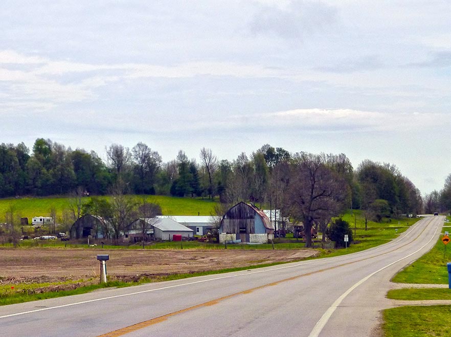
Figure 5. Crowley’s Ridge rises abruptly from the surrounding Delta land to a height of 150 feet above sea level.
Crowley’s Ridge runs north and south and is 1 mile to 12 miles wide extending from Scott County, Missouri, into eastern Arkansas. (Figure 5). When the Mississippi River abandoned the Advance Lowland, it cut through Crowley’s Ridge south of Scott County Hills. (Figures 6a and 6b). Before this happened, Crowley’s Ridge and Scott County Hills were one continuous land mass. The Mississippi River created a large gap from Bell City to Oran, Missouri. Land fragments of the old Crowley’s Ridge can be seen today northwest of Bell City. Bird, Cow, Lost and Ringer hills are isolated hills or knobs and formerly were a part of the main upland.
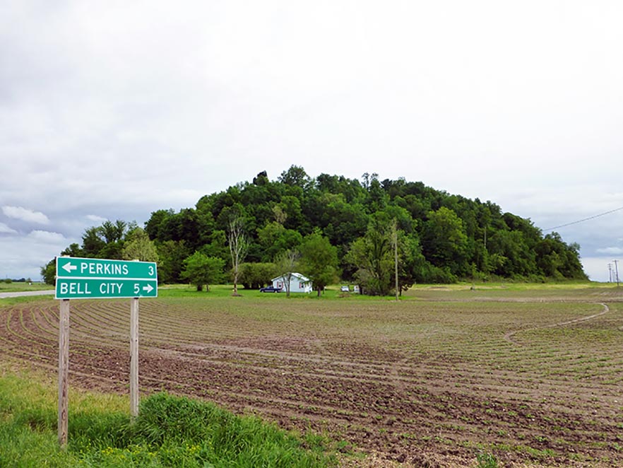
Figures 6a and 6b. Bird, Cow, and Ringer Hills are isolated land masses previously part of Crowley’s Ridge that survived the Mississippi River cutting through the Bell City-Oran Gap. Drive east of Advance, Missouri on County Highway O.
Western Lowland
The broad, almost level alluvial plain between the Ozark Escarpment and Crowley’s Ridge is the Western Lowland. It extends from Wappapello south to the Arkansas state line. It is the former Mississippi River Alluvial Valley, now occupied by the Black and St. Francis rivers (Figure 7). The aggraded valley has an elevation over 300 feet above sea level, and averages 15 feet to 25 feet higher than the lowland east of Crowley’s Ridge. With the possible exception of the Kennett and Sikeston ridges, the alluvial deposits here are older than those in other parts of the Delta.
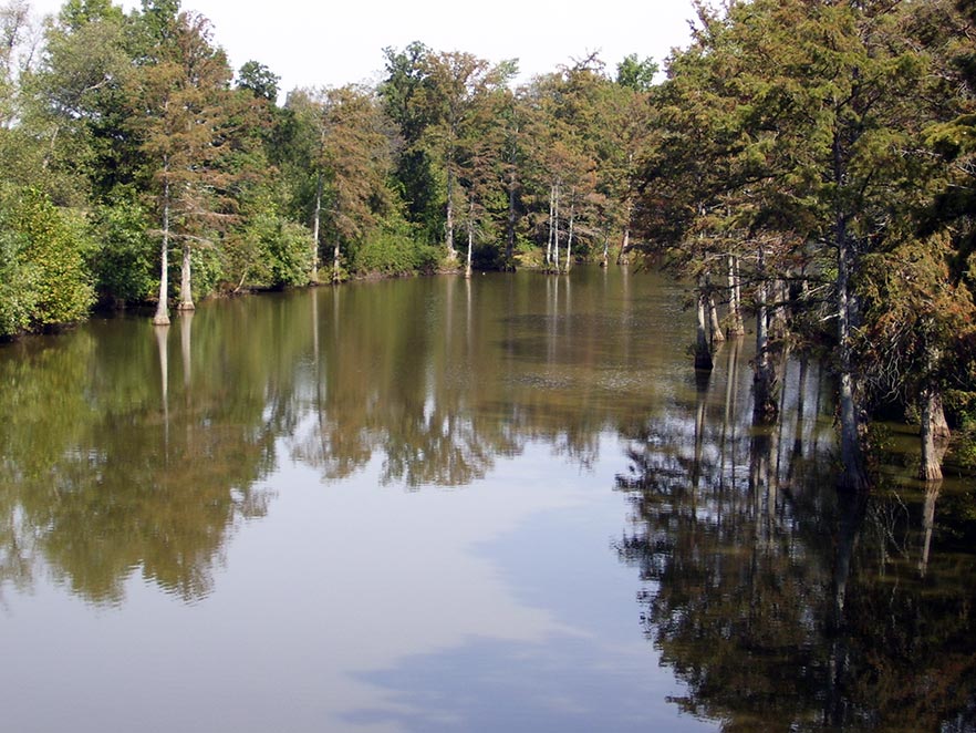
Figure 7. The Black River flows through the Western Lowlands.
Advance Lowland
The Advance Lowland includes the northern tip of the Lowland Region. It extends from Cape Girardeau west to the St. Francis River near Wappapello. It is bounded on the north by the Ozark Escarpment and on the south by Scott County Hills and Crowley’s Ridge. This subarea, like the Western Lowland, is the former alluvial valley of the Mississippi River. It has been filled by alluvial deposits of Castor, Whitewater, Hubble and other Ozark streams.
The loess-covered upland supplied vast quantities of sediment that covers and obscures the old drainage lines. The elevation at the town of Delta is 335 feet above sea level. The west end of Advance Lowland is blocked by the alluvial fan of the St. Francis River, resulting in the Mingo Swamp. (Figure 8). About 1 mile east of Advance, the former channel of the Mississippi River is marked by natural levees.
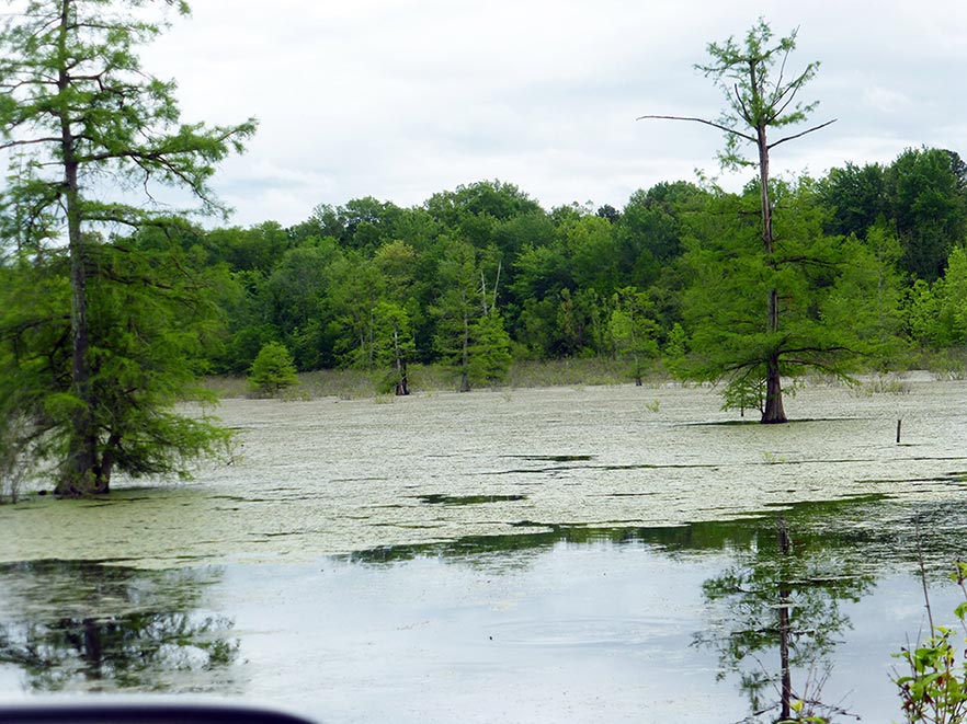
Figure 8. The Mingo Swamp near Puxico, Missouri, is part of the old channel of the Mississippi River before it shifted course east of Crowley’s Ridge.
Successive terraces conforming to the bend in the river became shorter going east. An unusual bog area is located in the Oran-Bell City Gap. It is probably a remnant of the abandoned Mississippi River channel that has been filled in with organic matter and sediment (Figure 9).
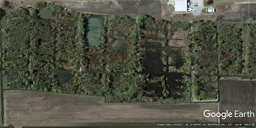
Figure 9. The photo shows an area of high organic soils which forms natural bogs surrounded by trees located on Stoddard County Road 347 near Oran, Missouri.
Kennett and Sikeston ridges
Kennett and Sikeston ridges are level, sandy terraces. They are similar in origin and are remnants of the Ohio alluvial plain, formed when the Ohio River occupied the lowland east of Crowley’s Ridge. The plain was degraded and destroyed by the Mississippi River when it shifted to occupy this section of the Delta. The ridges were formerly connected, and their edges are marked by slopes, indicating they were formed by stream erosion.
Sikeston Ridge is higher than Kennett Ridge. The towns of Sikeston and New Madrid are located on the Sikeston Ridge. The elevation of Sikeston is approximately 328 feet above sea level, and New Madrid is 295 feet above sea level. The towns of Kennett and Malden are located on the Kennett Ridge. The elevation of Kennett is 269 feet above sea level, and Malden is about 292 feet above sea level.
Both ridges have scars, swales and shallow sloughs, marks of the former Ohio River channels. These are most apparent north and west of Kennett. The area formerly known as Varney River Swamp west of Kennett is a former Ohio River channel. The St. Francis River now occupies an abandoned main channel of the braided Ohio system. Before canalization, the St. Francis River had a poorly defined channel and the exact location of the state boundary was difficult to identify.
Morehouse Lowland
The Morehouse Lowland is the largest subarea of the Delta and includes the area extending from Advance Lowland on the north to the Missouri-Arkansas state line on the south. It is bordered on the west by Crowley’s Ridge and Kennett Ridge, and on the east by Sikeston Ridge and the Mississippi River, south of New Madrid. It has an elevation of about 328 feet above sea level near Bell City and about 256 feet above sea level at the state line, or a slope of about 1 foot per mile. That portion of the Lowland south of Morehouse was formerly known as Little River Overflow, because of frequent inundation by water from Castor and Whitewater rivers.
A subarea of the Morehouse Lowland is a low sandy terrace east of Dexter and extending from Essex in the north to near Gideon in the south. The surface is marked by numerous marshy depressions from former channels of the braided Mississippi River. The broad, shallow swale in the eastern part of the Morehouse Lowland, and the bordering Sikeston Ridge, was probably the channel before it was abandoned by the Mississippi River. It was a swamp until drained. Except for the Essex terrace, most of the Morehouse Lowland is characterized by a level surface and clay soils.
The New Madrid earthquakes occurred in the winter of 1811 and spring of 1812. Reelfoot Lake in West Tennessee was created by the earthquakes. In Missouri, soils near New Madrid, Marston and Portageville were the most affected. The earthquakes caused landslides, uplifts, sunk lands, sand blows and fissures. Energy from the shaking caused pressure in subsoil sand saturated with water.
The sand was liquefied and forced upward to the surface in cracks and fissures (Figure 10). Smaller earthquakes are common along the New Madrid seismic zone running from southern Illinois and northwest Tennessee crossing the Mississippi River into southeast Missouri down to Jonesboro, Arkansas. Earthquake sand boils are common in crop fields. Sand has a low water-holding capacity compared to surrounding silt loam or clay soils in the field, so crops grown without irrigation in sand boils become water stressed quickly during periods of low rainfall (Figure 11).
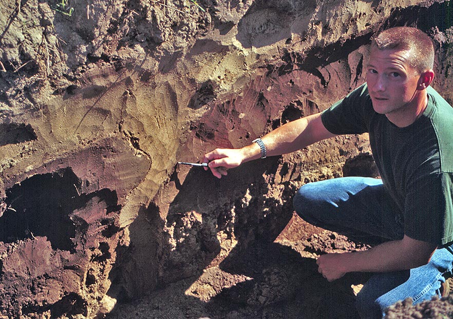
Figure 10. This profile of Crevasse loamy sand soil has sand filled fissures caused by the New Madrid Earthquake. The soil pit was located near Hayward, Missouri, in Pemiscot County.
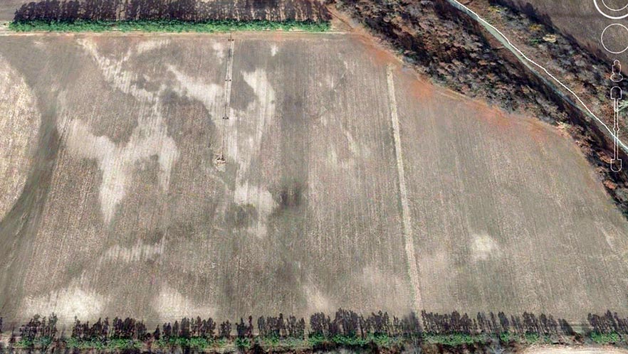
Figure 11. Light colored areas are sand boils caused by the New Madrid Earthquake. During periods of low rainfall crops are often water stressed.in these locations. (Photo from Google Earth south of Portageville, Missouri.)
Eastern Lowland
The Eastern Lowland lies south of Scott County Hills, east of Sikeston Ridge, and is bordered on the east by the Mississippi River. It is a lowland formed by the combined action of the Mississippi and Ohio rivers. It consists of two subareas called the Charleston terrace and the Mississippi meander belt. The Charleston terrace extends from Morley on the north to East Prairie on the south. The meander belt is the broad lowland bordering the Mississippi River and extending from the Scott County Hills to New Madrid.
The boundary between these subareas is an irregular escarpment, about 10 feet high, that extends from about 3 miles west of Commerce to about 6 miles south of East Prairie. The elevation at Charleston is 322 feet above sea level, which is about the same as Sikeston Ridge. The surface of the terrace is bisected by broad swales that mark the former channels of the braided Mississippi River. The surface of the meander belt is uneven because of natural levees and swales of former river meanders. It has the most recent alluvial deposits and was aggrading until protected by levees.
Soil genesis
The varied character of the soils of the Delta is due primarily to the soil-forming material and the drainage condition under which the soils developed. Alluvial sediments from the Mississippi and Ohio rivers are the parent material of the soils east of Crowley’s Ridge. The loess-covered hills of the Ozark Highlands and Crowley’s Ridge have eroded and deposited silt on the surface horizons of soils north and west of Crowley’s Ridge.
The soils of the Delta are geologically young and formed since the Wisconsin glacial age. The thickness of the alluvial material averages over 125 feet but is shallower in some areas. The alluvial soils were formed after the deposition of the loess, which covers the ridges. Loess is silt-sized sediment accumulated from wind-blown dust. The more recent deposits are in the flood plain of the Mississippi River and on the alluvial fans of the smaller streams.
The texture of alluvium parent material from different areas of the Delta varied. On the natural levees and low ridges, it was predominantly sandy. Clay was deposited in the wide slack water areas farthest away from the channels. Texture variations are more numerous and contrasting in the meander belt of the Mississippi River. The remnants of the Ohio alluvium of Kennett and Sikeston ridges is sandy. The Mississippi alluvium is predominantly clay or very fine sand. On the sandy ridges there is a gradation in texture from coarse to fine from north to south. This is most apparent on Kennett Ridge and on the Morley-Charleston sand area. The velocity of the rivers flowing south was decreased when they entered the Delta, and the coarse material was dropped first.
Differences in texture are associated with chemical and mineral differences. Coarser sands contain more quartz. Finer sands generally have a more complex mineralogical composition. The minerals in the recent Mississippi River deposits are fresh and slightly weathered. These are significant factors that help explain the differences in productivity of the sandy soils.
The predominantly silt texture of the soils in the Western and Advance lowlands indicates the close relationship of the alluvium to the loess mantled upland. This is the oldest alluvium in the Delta, except for Kennett and Sikeston ridges. The soils developed under poor drainage and have become thoroughly leached and weathered. Variations in the soils are due mainly to recent alluvial deposits by the Black River, St. Francis River and other streams.
Morphology of the soil
Soil morphology relates to the profile structure. Soil morphology of the lowlands in the Delta is expressed in faint horizons for the younger soils and moderate horizons for the older soils on the ridges and terraces. Highly developed profiles do not occur because all the soils are relatively young. Horizons are least distinct on the very sandy soils because of the low clay content. On the other extreme, horizons are also not distinct in heavy clay soils because of slow percolation. Horizons generally are most distinct in soils of intermediate texture as is evidenced by the Overcup, Dundee and Dubbs soils (Figure 12). Marked differences in texture within the profile, sand over clay, or clay over sand, are depositional layers, and not genetic horizons. Such stratified horizons are most frequent in the recent deposits near the Mississippi River. Regardless of the number of years since their deposition, the soils are in various stages of weathering and in range of development from slight to moderate. Differences in rate of weathering were governed by differences in the permeability of the soil forming material.
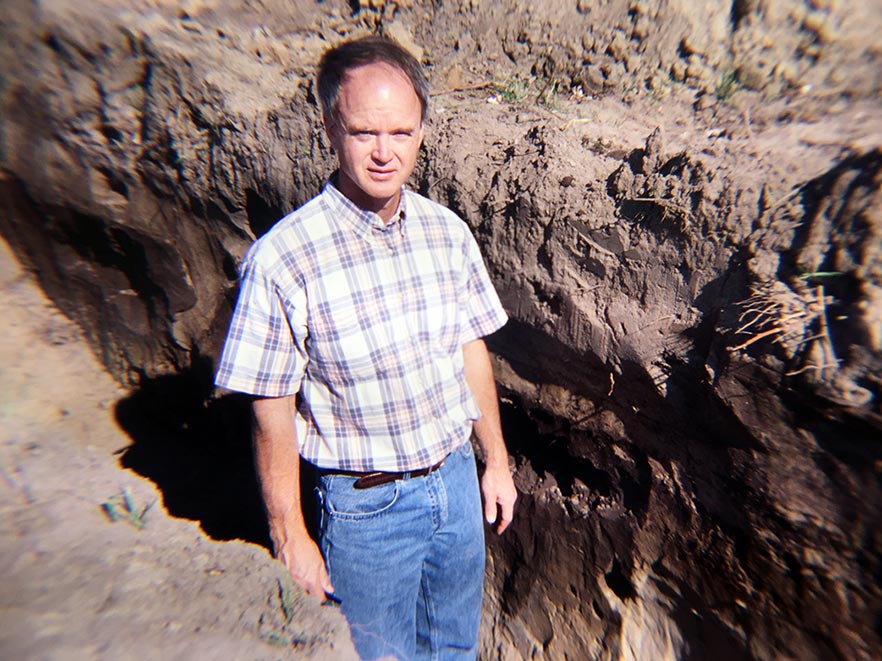
Figure 12. Soil horizons (A, B, and C) were identified in this Dubbs silt loam soils at Hayward, Missouri.
The accumulation of organic matter applies to all soils. It varies in depth and amount of accumulation, but usually is greatest in the clay soils. Organic matter in sandy soils is usually low. The content of organic matter decreases with depth, but its distribution throughout the profile indicates that it was deposited with the sand and clay and not distributed by translocation. This is especially evident in the deep black clay and muck areas.
Because of the high rainfall, all of the soils are leached of carbonates. The most recent deposits near the Mississippi River have been leached the least. Leaching has been most severe on the well-drained sandy soils, as indicated by the generally lower pH. The translocation of silicate clays generally does not occur until the carbonates have been removed.
Reduction and transfer of iron has occurred in the very poorly drained soils. This process known as gleying is the reason for the gray color and color horizons. In Sharkey clay (Figure 13) the gleyed zone may be 6 inches to 10 inches below the surface in one area, while at other places it may be at a depth of 2 feet or more. In general, the gleyed zone is higher in the profile in the southern part of the clay area than in the northern part because of the slower drainage. The reduced iron may be removed completely from the soil, or it may segregate in certain horizons to form concretions and mottles. The loss of iron is indicated by the high mineralization of the ground water. Concretions and mottles are common in soils. They are generally most abundant in depressions or places of standing water. Soils containing many concretions have a harsh brittle structure and are characterized by low fertility.
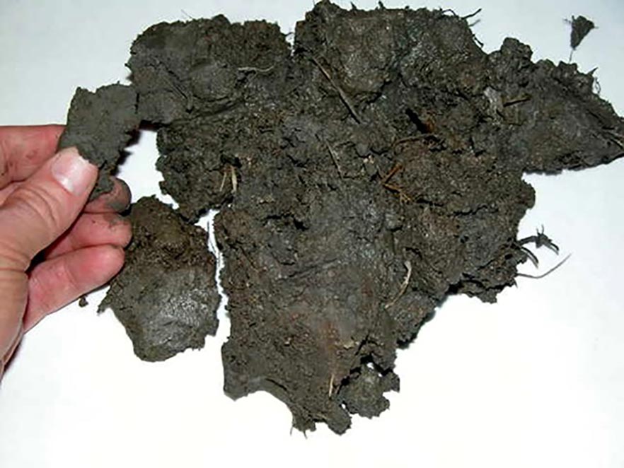
Figure 13. Soil from the surface A horizon in a Sharkey clay soil. Sharkey clay soils are high in shrink-swell clay which is sticky when wet and cracks in dry weather.
Soil classification
Soil types in the Delta region are classified by texture, color, soil profile development and relief or elevation of the land. The soil series is the lowest category of the national soil classification system. The name of a soil series is the common reference term, used to name soil map units. The location of dominant soil series in the region are shown in Figures 14-19 (beginning on page 9) listed by drainage (excessive drainage to poorly drained). Graphs were made with the U.S. Department of Agriculture Natural Resource Series Extent Explorer program. This list does not include all the soil series found in the Delta. Shown below are brief descriptions of the soil series. Most of the text is from Missouri General Soil Map and Soil Association Description released in 1979 by USDA-Soil Conservation Service and University of Missouri Experiment Station.
Excessively drained
- Broseley is a deep, well and somewhat excessively drained soil formed in sandy alluvial deposits. It is generally located at a higher elevation than either Bosket or Dubbs. It has a loamy fine sandy surface soil overlying a fine sandy loam and sandy clay loam subsoil that has moderately rapid permeability. Slopes commonly range from 0% to 6 % with small areas having slopes up to 12%.
- Malden is a very deep, excessively drained, gently undulating to nearly level soil formed in sandy alluvium on natural levees and terraces. It has a fine sand surface soil overlying a rapidly permeable loamy fine sand subsoil.
- Scotco is a very deep, excessively drained, sandy, rapidly permeable soil formed in sandy alluvium on broad, old natural levees. It has a sand surface soil overlying a rapidly permeable sand subsoil.
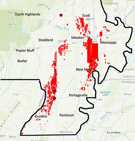
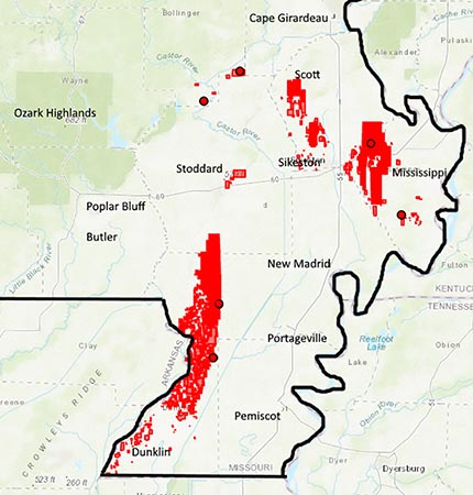
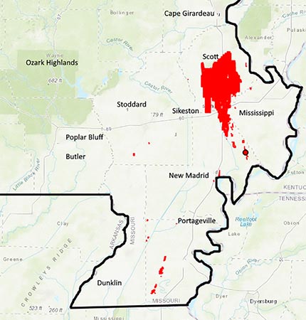
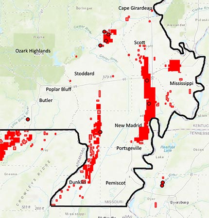
Figure 14. Locations (left to right) of Broseley, Malden, Scotco (excessively drained) and Bosket (well drained) soil series in Southeast Missouri. Data and graphs from Natural Resources Conservation Service-Series Extent Explorer.
Well drained
- Bosket is a very deep, well-drained soil formed in loamy alluvium. It has a fine sandy loam surface soil overlying a moderately permeable sandy clay loam subsoil.
- Dubbs is a very deep, well-drained soil formed in loamy alluvium. It has a silt loam surface soil over-lying a moderately permeable silty clay loam subsoil.
- Memphis is a deep, well-drained soil formed in loess deposits on uplands and terraces. It has a silt loam surface soil overlying a moderately permeable silty clay loam subsoil. Slopes range from 0% to 20% with small areas having slopes up to 40%.
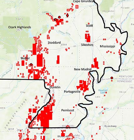
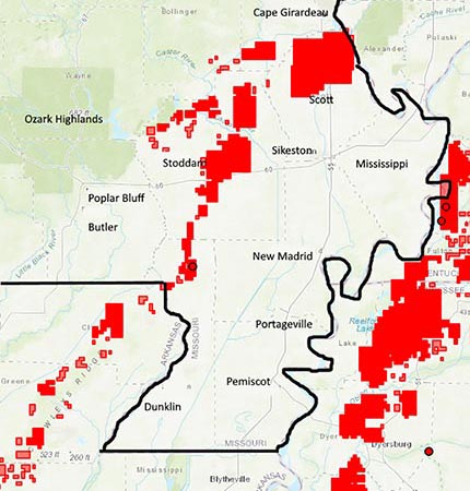
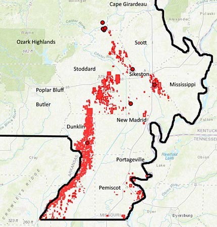
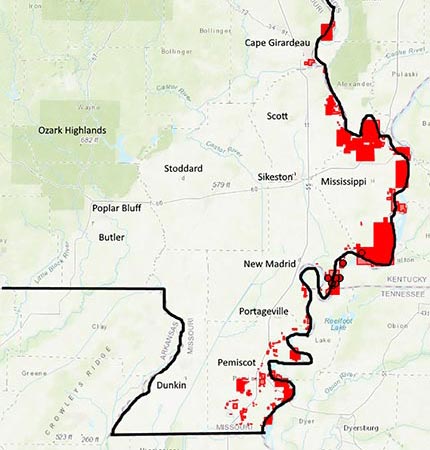
Figure 15. Locations (left to right) of Dubbs, Memphis (well drained), Canalou, and Carthersville (moderately well drained) soil series in Southeast Missouri. Data and graphs from Natural Resources Conservation Service-Series Extent Explorer.
Moderately well drained
- Canalou is a very deep, moderately well-drained, with moderate rapidly permeable subsoil formed in sandy alluvium on level to nearly level or slightly undulating terraces or old natural levees.
- Caruthersville is a deep, moderately well drained soil formed in loamy alluvium on the higher elevations bordering the Mississippi River channel. It has a very fine sandy loam surface soil overlying a moderately permeable, very fine sandy loam subsoil.
- Loring is a deep, moderately well drained soil formed in loess and has a fragipan. It has a silt loam surface soil and a moderately permeable silt loam subsoil underlain by a massive, compact, brittle fragipan. Slopes range from 0% to 15%.
- Silverdale is a deep, moderately well drained soil formed in sandy sediments over loamy alluvium in slightly concave micro depressions on natural levees. It has a loamy sand surface soil with a rapidly permeable sandy subsoil that is underlain by silt loam.
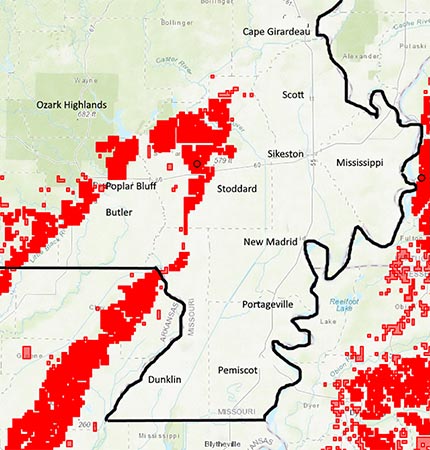
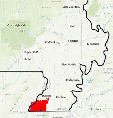
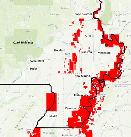
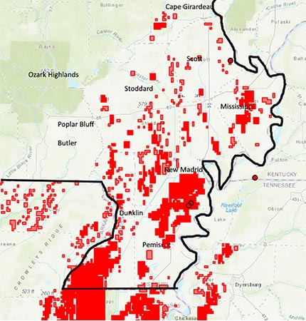
Figure 16. Locations (left to right) of Loring, Silverdale (moderately well drained), Commerce, and Dundee (somewhat poorly drained) soil series in Southeast Missouri. Data and graphs from Natural Resources Conservation Service-Series Extent Explorer.
Somewhat poorly drained
- Commerce is a deep, somewhat poorly drained soil formed in loamy alluvium. It has a silt loam or silty clay loam surface soil overlying a silt loam or silty clay loam subsoil that has moderately slow permeability.
- Dundee is a very deep, somewhat poorly drained soil formed in loamy alluvium on low terraces or natural levees. It has a loam surface soil overlying a clay loam subsoil that has moderately slow permeability.
- Falaya is a very deep, somewhat poorly drained soil formed in silty alluvium. It has a silt loam surface over a moderately permeable, silt loam subsoil. Flooding is common unless protected by levees.
- Lilbourn is a very deep, somewhat poorly drained moderately permeable soil formed in loamy alluvium of recent deposition over buried alluvium of older age on nearly level to depressional terraces or natural levees. It has a fine sandy loam surface soil over a moderately permeable, fine sandy loam subsoil.
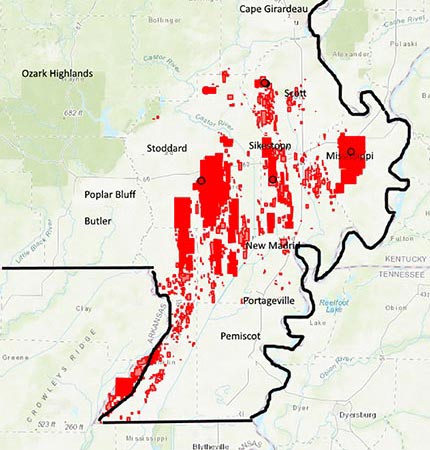
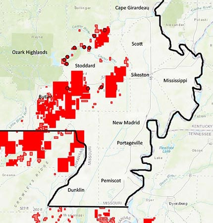
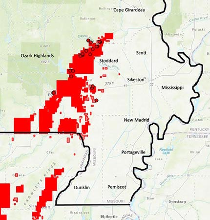
Figure 17. Locations (left to right) of Falaya, Lilbourn (somewhat poorly drained), Amagon, and Calhoun (poorly drained) soil series in Southeast Missouri. Data and graphs from Natural Resources Conservation Service-Series Extent Explorer.
Poorly drained
- Amagon is a very deep, poorly drained soil formed in loamy alluvium. It has a silt loam surface soil overlying a slowly permeable, silty clay loam subsoil.
- Calhoun is a deep, poorly drained soil formed in loess on low terraces or in slightly depressional areas of high terraces. It has a silt loam surface soil overlying a slowly permeable, silty clay loam subsoil.
- Gideon is a very deep, poorly drained soil formed in loamy alluvium on floodplains and depressional areas. It has a loam surface soil overlying a moderately slow permeable, clay loam and sandy clay loam subsoil.
- Hayti is a very deep, poorly drained soil formed in loamy alluvium in depressional areas of the flood plains. It has a silty clay loam surface soil overlying a slowly permeable, silty clay loam subsoil.
- Overcup is very deep, poorly drained, very slowly permeable soil formed in alluvium. It has a silt loam surface soil overlying a slowly permeable, silty clay subsoil.
- Sharkey is a deep, poorly drained soil that has a clayey surface soil overlying a slow or very slowly permeable clay subsoil.
- Sikeston is a very deep, poorly and very drained soil formed in clayey alluvium. It has a clay surface soil overlying a clay subsoil that has very slow permeability.
- Tuckerman is a very deep, poorly drained low terrace soil formed in loamy alluvium. It has a loam surface soil, overlying a loam to clay loam subsoil that has moderately slow permeability.
- Wardell is a very deep, poorly drained soil formed in loamy alluvium on old natural levees and flood plains. It has a loam surface soil overlying a slowly permeable clay loam subsoil.
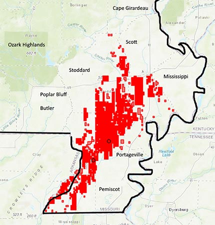
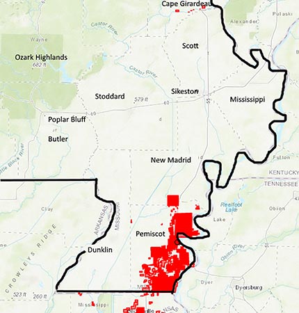
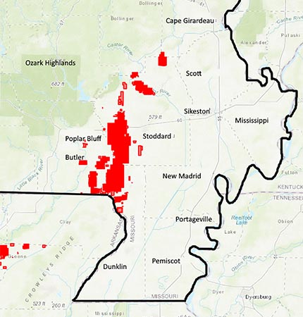
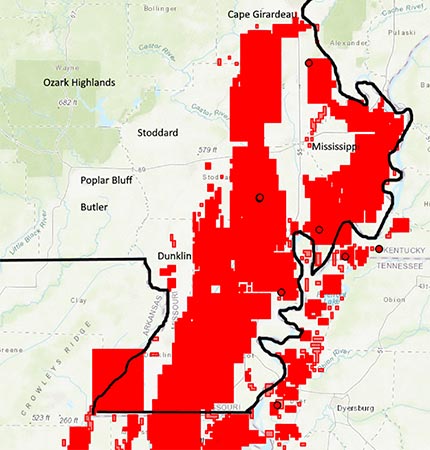
Figure 18. Locations (left to right) of Gideon, Hayti, Overcup, and Sharkey (poorly drained) soil series in Southeast Missouri. Data and graphs from Natural Resources Conservation Service-Series Extent Explorer.
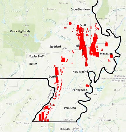
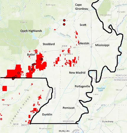
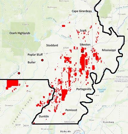
Figure 19. Locations (left to right) of Sikeston, Tuckerman and Wardell (poorly drained) soil series in Southeast Missouri. Data and graphs from Natural Resources Conservation Service-Series Extent Explorer.
Two dominant soil series in the Western Lowland are Calhoun and Overcup (Figures 17 and 18). They also occur in other lowland subareas. They are important for rice production in Missouri. The soils of the Western Lowland are distinguishable from the soils of other sections of the Lowland region by the light gray color, silty texture, slow internal drainage, and signs of leaching. The fields had low fertility before farmers started applying inorganic fertilizer. These soils occur between Crowley’s Ridge on the east and the St. Francis River, in Stoddard and Dunklin counties. It forms a terrace that is 5 feet or more higher than the bottomland west of the river. It is part of the former Mississippi alluvial plain that has been aggraded by a vast amount of silt washed from Crowley’s Ridge. The slight but general slope of the land is to the West.
Sharkey clay is the most extensive soil area in the Delta (Figure 18). Farmers often call it “Gumbo.” It extends as a continuous band from the southern part of Cape Girardeau County south to the Arkansas state line. The entire area is characterized by a level surface and dark clay soil. The surface soil, usually about 6 inches in depth, is a dark gray (black when wet) silty clay or clay or clay loam that has a dark gray or yellow gray plastic clay subsoil with yellow and brown mottling. The subsoil below 20 inches to 24 inches is a dull gray to bluish gray plastic clay that extends to a depth of many feet. Nearly everywhere coarse grains of sand are disseminated through the soil mass, but they are most abundant in the surface. Sand pockets, 2 feet or more in diameter, or yellow-brown coarse sand may occur at various depths. The Sharkey clay is difficult to cultivate. Depth of plowing is about 5 inches. Both surface and internal drainage is slow. In wet seasons planting may be delayed for several weeks.
The soils on Kennett and Sikeston ridges are similar in origin and morphological features (Figures 14-16). All are sandy but there is regional variation in degree of sandiness. This is significant because it affects the moisture holding and general productiveness of the soils. The portion of Kennett Ridge between Gibson and Kennett has an uneven surface because of numerous swales or depressions. These have a northeast-southwest trend and are remnants of former stream channels. The soil in these low places varies from gray sandy loam to sandy clay loam. It is poorly drained and less productive than the higher lying sands. Drainage is provided by open ditches. Sikeston Ridge is a distinct soil area that stands about 15 feet higher than the surrounding darker and heavier textured bottomland. The dominant soils on the ridge are brown sandy loams that vary from dark brown loam in slight depression to light brown fine sand on the slight ridges. Below the surface, the color changes to yellow brown, and may be mottled yellow and brown below 30 inches. There is little change in texture, although in many places the lower subsoil is a brown silty clay or sandy clay loam. This horizon is depositional in origin and is not due to soil-forming processes. In general, the soil along the western edge of Sikeston Ridge is deep, loose sand that tends to blow. The Dundee soils form the large area of moderately sandy land east of Kennett Ridge, extending from Essex on the north to Gideon on the south. It is a low terrace that has distinct boundaries except on the south where it grades into Sharkey clay soils. The soil material is old alluvium deposited or reworked by the Mississippi River when it occupied the Morehouse Lowland.
Memphis and Loring series are important in Upland areas (Figures 15-16). The Upland soils are located at Scott County Hills, Crowley’s Ridge, Hickory Ridge, Baker Hill, Goose Pond Hill, and the small isolated hills named Bird, Cow, Ringer and Lost. The soils are covered by 10 feet to 20 feet of loess. Loess is silt-sized sediment accumulated from wind-blown dust. The greatest thickness of loess is at the eastern part of the Scott County Hills. The surface horizon of these soils is usually silt loam. The soils are geologically old compared to alluvial Delta soils. On many slopes the surface has been eroded 5 feet or more exposing the underlying sand and gravel deposits. The eroded loess material has accumulated on the lowland soils west of Crowley’s Ridge where most of the rice is grown in Missouri.
Flood control, drainage and clearing
The upland and high terraces generally were well-drained and the first to be developed for agriculture. Most other land was subject to flooding from rivers and rains. Protection from overflow was the first requirement before the land could be farmed.
The first levee along the Mississippi River was built in 1900 and has been rebuilt and heightened several times until flooding from the river has been eliminated. The spillway levee from Birds Point to New Madrid, built in 1935, was designed by the U.S. Army Corps of Engineers to be blown when needed to lower the flood stages upstream on the Ohio River. Cairo, Illinois, is the closest town on the Ohio River in danger of flooding (Figure 20).
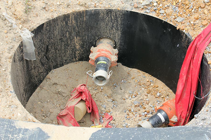
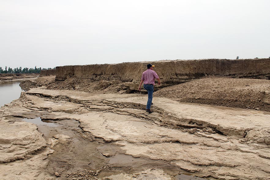
Figure 20. The Birds Point Floodway was activated in January, 1937, and May, 2011, by the Army Corps of Engineers. The top photo, taken in 2011, shows a slurry port in an unblown levee section. The bottom photo shows deep soil cuts created by rushing water at O’Bryan’s Ridge in the Floodway.
The most significant flood protection project for Missouri farmers in the Delta is the Little River Drainage System, completed in 1926. The headwater diversion channel deflected the water from Castor River, Whitewater River and other Ozark streams into the Mississippi River a short distance south of Cape Girardeau, Missouri (Figure 21). Before this, much of the Morehouse Lowland flooded during the winter and spring. The Little River Drainage District includes 488,000 acres and extends from the Ozark Escarpment south to the Arkansas state line. The district includes 937 miles of dredged ditches and 304 miles of levees. Payment on the drainage bonds was completed in 1952.
Figure 21. The diversion channels of the Little River Drainage District include 937 miles of drainage ditches.
Development in the Western Lowland was slow until flood control by levees had been established on the St. Francis and Black rivers. Wappapello and Clearwater reservoirs on the two streams further reduced the danger of flood. Extensive drainage by ditches had been developed previous to 1900, mainly in Pemiscot, New Madrid and Scott counties. The first drainage districts were relatively small, but as drainage developed, unification of districts became necessary. Not all districts were financially successful.
Excluding the high terraces, practically all the land is subject to drainage and levee tax. For most districts, drainage taxes are used for removal of vegetation, periodic clean-out of ditches, and maintenance of levees. The time between re-dredging or clean-out of a ditch is usually 5 years to 12 years, depending on type of soil and rainfall.
Conversion of the Delta from forest to cultivated land was important to regional development. Originally all of the land except small areas on the higher sand ridges was heavily forested. It is estimated that in 1900 only 15% of the total land area was forested. Most of the remaining forest is in the Western Lowland and inside the levee areas along the Mississippi and other rivers.
Most of the early tree clearing was by ax, saw and fire. The later clearing was done by bulldozers. Trees were usually cut and burned. The larger trees were cut and milled. There were large sawmills at Morehouse, Gideon, Kennett, Deering, Caruthersville and Poplar Bluff that operated a network of tram lines. The sites of many mills later developed into permanent villages. Lumbering was a major industry from 1890-1930.
Clearing followed logging. Fires and a haze of wood smoke from piles of stumps were a common sight in the spring. The toil and hardships of the settlers that cleared the land have not been fully recognized. Inferior homes, no roads, wetland and low wages were the norm. The cost of clearing ranged from $10 an acre to $20 an acre. As the forests disappeared, former loggers became land clearers, and then turned to farming. It was a transition period for land and people, from forest to cultivated field, and from woodsman to farmer.
The economy in the Delta changed during this period. Much of the land was in large holdings by lumber companies, railroads and investors. Clearing required much labor, and the cost of reclamation required capital, which tended to eliminate the small landowner. Owners leased the land to tenants and sharecroppers, and many small farm units from 40 acres to 80 acres were established. In 1910, U.S. Census records show New Madrid County had 1,593 farms. The number of farms steadily increased to 3,857 in 1950, and more than 77% of the farmers were classified as tenants. However, by 1960, the number of farms had declined again to 2,108. Mechanization reduces the need for labor, and a higher level of production lowers costs (economy of scale). A USDA survey in 2017 showed only 290 farms in New Madrid County and 5,244 farms in the 11 counties that are in all or part of the Delta.
Changes in soils due to the action of humans
Significant changes in the morphological properties of the soils have resulted from the action of humans, including removal of the forest, reduced flooding, extensive drainage, land grading and frequent cultivation. The development of horizons in soils over time results from accumulation of organic matter, leaching of carbonates and soluble salts, translocation of silicate clay minerals, and reduction and transfer of iron. Farming activities sometime disrupt horizon development.
Most land areas are no longer subject to prolonged floodwater inundation. Land forming or land leveling is a form of soil management that has been adopted in recent years (Figure 22). Its purpose is to eliminate low places and depressions in fields and to provide better surface drainage. The water table has been lowered, reduction processes have been slowed, and aeration extends to a greater depth. Because of better oxidation, many of the light gray soils have acquired a brownish color at the surface. The deep drying of the clay soils has caused them to be more granular, less sticky and more easily tilled.
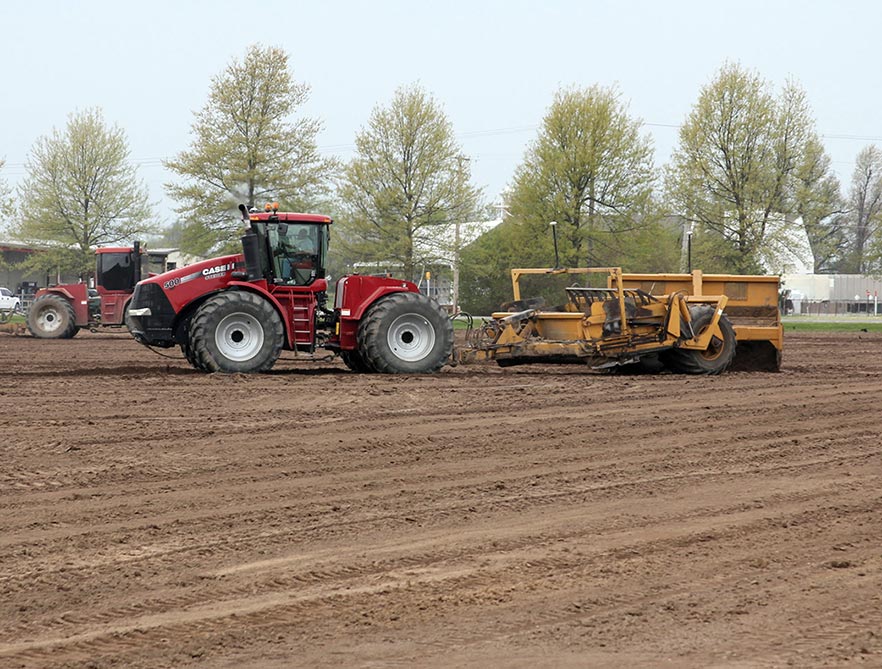
Figure 22. GPS guided land grading is used to improve drainage and uniformity of water application with furrow irrigation.
Delta farmers often plant crops on beds to promote warmer soil temperature during seed germination and minimize waterlogged soil conditions. In bedded fields, part of the bedded surface is at an angle to the sun most of the day. This increases the amount of heat absorbed by the surface and transmitted to the seed and root level. Also, wind hits a larger area in bedded fields and soil evaporation is increased, which helps dry the soil.
The size of fields has increased to accommodate larger field equipment. Farmers are able to plant more acres in a day. The downside is few structures exist to break the wind, which is a hazard in the flat Delta terrain. Fence rows and trees along field borders have been removed. Strong winds before storms have caused brown clouds filled with dry soil reminiscent of the Dust Bowl in the Plains. Sandstorms in mid-May injured cotton seedlings causing delayed early plant growth in Pemiscot, Dunklin and New Madrid counties in the 1980s and early 1990s. Some fields had to be replanted. Beginning in the late 1990s, it became common for farmers to plant wheat between rows to minimize blowing soils in spring storms (Figure 23).
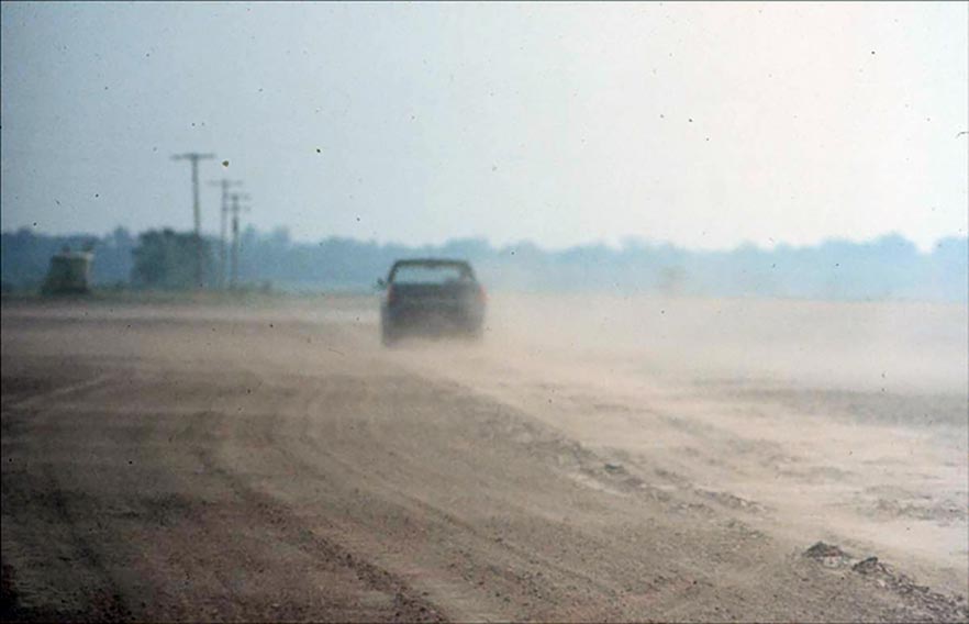
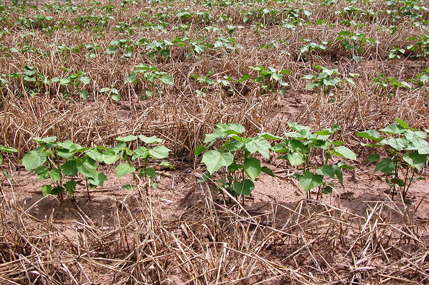
Figure 23. Sand storm near Hayward, Missouri in 1995 (top). Wheat is planted and killed in cotton row middles to reduce blowing sand.
The removal of the forest and the cultivation of the land has reduced organic matter content in soils. The clay soils have become lighter in color and the sandy soils have a greater tendency for compaction or crusting. Protection from flooding by levees and ditches has eliminated sedimentation, especially along the Mississippi and St. Francis rivers. The greatest change has resulted from drainage.
Conservation tillage, combined with winter cover crops, has helped increase soil microorganisms and earthworms. In some fields, farmers plant winter cover crops for soil health in addition to wind protection (Figure 24). Seed blends include one or more of the following: wheat, rye, radish, rapeseed, Austrian winter peas, hairy vetch and crimson clover.
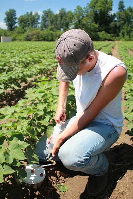 Figure 24. A worker from the Delta Research Center extracts air from a buried ring in a cotton field to measure soil CO2 levels as an indication of microbial respiration.
Most of the alluvial soils are fertile, deep, and retain productivity under continued cultivation. During the early development period previous to World War II, little effort was made toward soil fertility improvement. The prevailing opinion was that it was not needed. Farmers were more concerned with clearing and draining the land. Where wheat was grown, clover was included for hay and soil improvement. The decline in productivity of sandy soils prompted the greater use of lespedeza, vetch, crimson clover and crotalaria. Production of these resulted in the use of limestone to a small extent, mainly in Scott and Stoddard counties.
Before the use of inorganic fertilizers, the soils in the Western Lowlands had the least plant nutrients and produced the lowest yields. Soils east of Crowley’s Ridge were generally more fertile because of more recent sediment deposits. In 1930, potassium fertilizer began to be used on cotton in Dunklin County. At first, fertilizer was used mainly on the sandy soils. The use of fertilizer in the rest of the Delta began following World War II. Crop yields in all lowland subregions increased with the application of inorganic fertilizers. Today, potassium deficiency in crops is more common than phosphorus deficiency.
Anhydrous ammonia, ammonium nitrate and urea are the main nitrogen sources for crops. The most common nitrogen fertilizer is urea. Compared to ammonium nitrate, urea has a higher percent nitrogen content, which reduces freight costs. The downside to urea is that significant nitrogen losses can occur by volatilization when it is broadcast on wet soil. To reduce losses, farmers often pretreat urea with a urease inhibitor stabilizer.
Limestone is used to neutralize soil acidity in fields. Sandy soils are weakly buffered and need liming more often than clay soils. The optimum pH for most crops is 6.5 to 7.0. The availability of aluminum and manganese often reach toxic levels in plants when soil pH is below 5.0. In a rice-soybean rotation, farmers should lime in the year before soybeans are planted to avoid zinc deficiency in rice from short term soil alkalinity.
In the past, the conventional wisdom was that enough sulfur becomes available to crops by rainfall deposition or organic matter decomposition. This is less likely to be true today. Reductions in air pollution have increased crop sulfur fertilization. One of the goals of the U.S. Clean Air Act of 1970 was to reduce “acid rain.” To comply with Environmental Protection Agency standards for sulfur dioxide gas emissions, many power facilities have switched to burning low-sulfur Western United States subbituminous coal. Sulfur fertilizer is recommended for Delta fields when laboratory soil tests show less than 7.5 parts per million sulfur on soils less than 6.5 CEC (cation exchange capacity).
Crops
Historically, large-scale farming in the Delta region has been limited to crops. Animal production is small compared to the rest of Missouri. Early farmers raised horses and mules to pull wagons and plows, and chickens, cows and pigs for feeding their families. Recently, poultry production has grown in the northern counties. Commercial chicken houses are located near Sikeston and Dexter.
Wheat was one of the first crops grown in the Delta. In the late 1800s, grain mills for processing wheat were built in Cape Girardeau, Dexter, Charleston, Sikeston, Oran and Advance. Wheat was formerly a major crop, especially on the sandy acreage in Scott County, but production declined after World War I.
Cotton acreage increased greatly after 1921 and largely replaced wheat. Cotton is a dominant commodity on well-drained soils in Pemiscot, Dunklin and New Madrid counties. In wet conditions cotton seedlings are susceptible to root rot (Pythium and Rhizoctonia). Bosket fine sandy loam, Dundee silt loam, and Dubbs silt loam soil types are important for cotton production in the Senath and Hornersville area. The boll weevil was a major cotton insect pest but was eradicated in a program sponsored by the USDA starting in 2001.
Delta farmers are a major producer of fiber for the world despite the loss of the textile industry in the United States. New technologies have been adopted by cotton farmers. Earlier maturing varieties, fertilizers and irrigation have resulted in increased yields. The use of mechanical pickers and sprayers for weed control changed production methods. The cost of labor for cultivation and harvesting has been reduced, and the time of harvest has been shortened.
Corn and soybeans are often grown in rotation to maximize yields and disrupt pest cycles. Year to year fluctuations in planted acres for each crop are due to spring weather, domestic and international market demand, and government programs. Loamy fine sand soils are important soils for growing corn near Charleston, Missouri. On sandy soils, center pivots are used to apply irrigation water. New corn hybrids tolerate more plants per acre. Most of the corn is sold as cash grain crop and processed for commercial animal feed.
Soybeans emerged as an important crop in the Delta around 1950. Before then it was mainly grown for hay. It is a versatile crop and can be grown on most Delta soils. Soybeans can tolerate waterlogged soils better than cotton and corn. It is often rotated with rice and double cropped with wheat.
In New Madrid County soybean acreage increased drastically over the years:
- 14,972 in 1940
- 82,946 in 1950
- 146,425 in 1960
- 210,000 in 2018
The greatest increase was on the clay soils and on the light-colored soils in the Western Lowland. The soybean cyst nematode is a major pest that reduces yields. The Soybean Breeding Program at the Fisher Delta Research Center has released many new varieties with improved disease and soybean cyst nematode resistance.
Rice was not listed as a crop grown in the Missouri Delta in the first edition of this bulletin written in 1966. In 1973, the U.S. Congress lifted acre allotment limits on Missouri rice. Today, Missouri’s annual rice production is usually around 200,000 acres. Rice soils contain enough clay to retain water during flood irrigation. Most of the rice is grown west of Crowley’s Ridge, but production is expanding in fields with Sharkey clay soil using furrow irrigation in other areas. Overcup silt loam and Calhoun silt loam soil types are major rice soils in the Qulin, Missouri, area. These soils have silt loam in the top 8 inches to 24 inches with silty clay in the subsoil. During tillage, soils with silt loam surface horizons do not form large clods as much as Sharkey clay.
Other important crops in the Delta are watermelons, peaches, potatoes and purple hull peas. Potatoes are grown on sandy soils and are processed for making potato chips. Peanuts and sweet potatoes are also grown in the Delta.
Irrigation
Irrigation is sustainable in the Delta because of groundwater recharge from rainfall on sandy ridges. Water penetration through sandy soil is high in the Kennett Ridge, Charleston and East Prairie areas. The general direction of water movement in the alluvial aquifer is north to south in the Delta region. Groundwater recharge in the Advance and Western Lowlands occurs from the Ozark Highlands where karst topography with sinkholes are prevalent. In a losing stream, water infiltrates into the groundwater as it flows downstream. A tracer study showed that dye introduced into a losing stream was detected 16 days later at Big Spring, 40 miles away near Mountain View, Missouri. The amount of groundwater recharge in the Morehouse and Eastern Lowlands from the Ozark Highlands is not known. Deep substratum layers below Crowley’s Ridge may slow west to east water movement in the aquifer.
Irrigation water is applied to corn, cotton, soybeans and rice based on daily crop water use. The method of irrigation depends on the crop planted and the soil properties. Flood irrigation was adopted for the production of rice, mainly on soils with high clay content. Furrow irrigation on other crops became important. Farmers first constructed supply ditches, but these often interfered with normal surface drainage of the field. Then, gated aluminum pipes were used to supply water from wells to furrows. Later, in the early 1990s, aluminum pipes were replaced by disposable lay-flat plastic tubing (Figure 25). Less labor is required to install plastic tubing, and it can be rolled up at the end of the growing season for recycling. To assure uniform distribution of water with furrow irrigation, most fields have been graded.
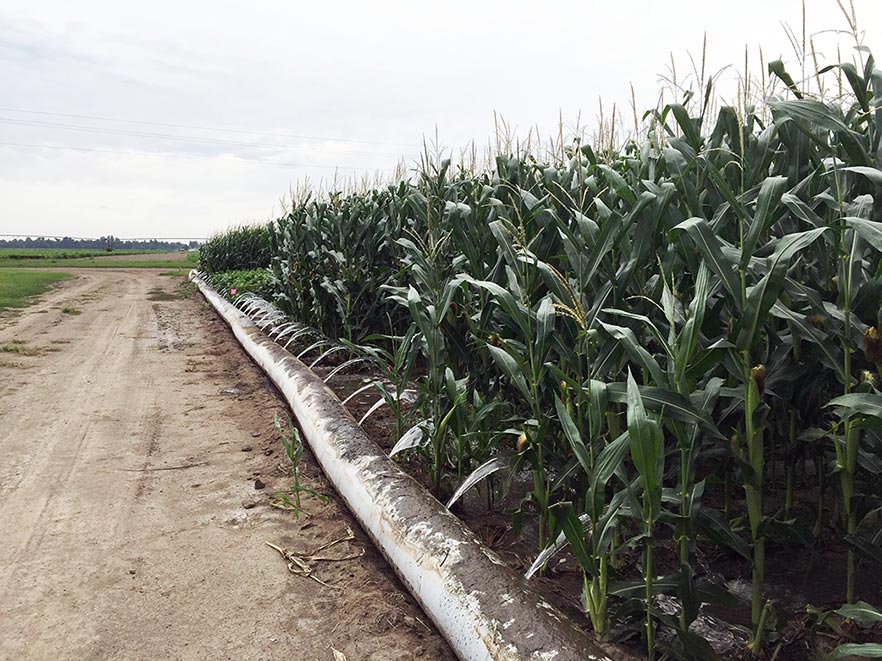
Figure 25. Holes are punched in lay-flat plastic pipe to supply water to row furrows.
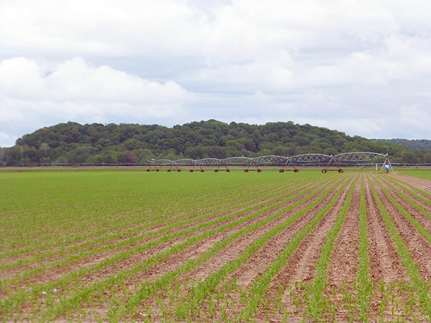
Center pivot irrigation systems are common especially on sandy soils. The machinery cost for a pivot is more than a furrow system, but, depending on the field, farmers could save money by not land leveling (Figure 26). Most center pivots are programable to turn on and off and can be used with injection pumps for chemigation. Systems have been developed to vary irrigation rates based on different soils in a field.
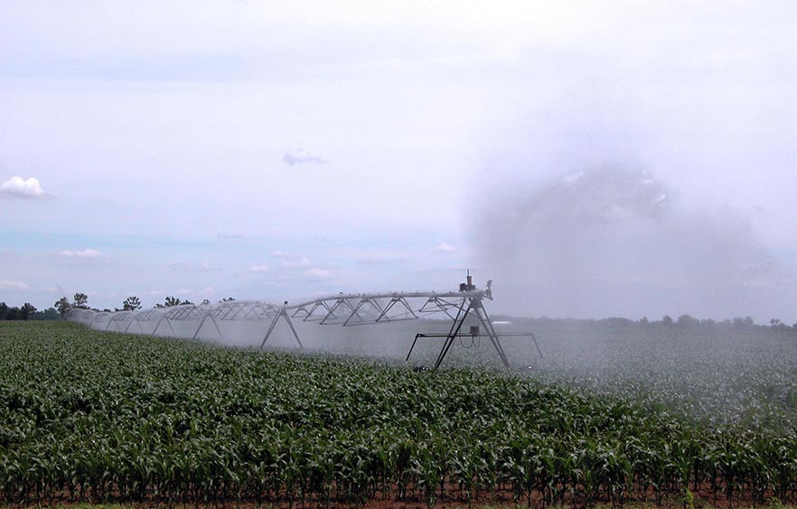
Figure 26. Center pivot irrigation systems use an end gun to apply water beyond the circle.
In the Delta region, water tables are usually below the depth of root penetration. The water table is highest at the Mingo Swamp in the Advance Lowland. Here the underground water from the Ozark Highlands tends to rise in the alluvial material by hydrostatic pressure. A shallow water table, normally more than three feet below the surface, exists in the swales bordering Kennett and Sikeston ridges, and in the Blodgett sand area.
Climate
The summers in Southeast Missouri are hot and humid, and the winters are usually moderate. Annual average temperature and rainfall are higher than for other parts of the state.
Precipitation averages 49 inches, but varies 5 inches to 10 inches from year to year. Heavy rains in the spring sometimes cause runoff beyond the capacity of drainage ditches. At such times, low lying land may be inundated for several days. Planting is often delayed in wet springs. Dry periods of two weels to four weeks in duration occur in late summer or early fall, reducing yields, unless irrigation is applied. The very sandy and the gray soils are affected the most by dry weather. Low rainfall is desirable in the fall during harvest. Snow may occur during the three winter months, but usually it is light and does not remain for more than three days to five days. Days with below zero degrees Fahrenheit are rare. The prevailing wind in the summer is from the southwest. Hailstorms and tornadoes do occur, but are no more frequent than in any other part of Missouri
The average date of the last killing freeze in the spring is the last week in March or the first few days in April. The average date of first killing freeze in the fall is about the first of November. The average growing season is more than 200 days, which is adequate for the maturing of cotton and rice. The variation in frost-free days because of late spring frosts from north to south within the Delta is about 10 days. This seemingly small difference is responsible for the smaller cotton acreage north of Sikeston. The generally long growing season permits the maturing of double-crop soybean planted after wheat, and the sowing of winter wheat after cotton harvest.
The University of Missouri Extension takes some of the guesswork out of crop management for farmers with its statewide network of electronic weather stations. The stations monitor weather factors including soil temperature, which is important for planting decisions. Wind speed is used by farmers to avoid drift from pesticide spraying. Most of the stations operate in “real time,” meaning they update every five minutes. Farmers can monitor weather from a nearby station by bookmarking the station’s website on their cellphone. To find a station near you, go to http://agebb.missouri.edu/weather/stations/ and select a location under the “Real-Time Conditions” header.
The USDA-Natural Resources Conservation operates a soil climate, automated weather station in Stoddard County on a Falaya soil. In the previous two decades, the warmest recorded average annual air temperature was in 2017 and the coldest recorded average annual air temperature was in 2015.
Transportation
The Delta region of Southeast Missouri has a good infrastructure for moving agricultural freight. Railroads, river barges and trucks supply bulk inputs such as fertilizer to the area and transport harvested grain and cotton to markets. The Mississippi River has been a means of transportation from pioneer times to the present. Boats from New Orleans traveled the river as far north as St. Louis and beyond.
Port harbors on the Mississippi River provide farmers access to buyers with elevators to load grain on barges. Barges carry grain to the Gulf of Mexico where it is loaded on ships for international markets (Figure 27). Cape Girardeau, Commerce, Cairo, New Madrid and Caruthersville are important river ports where large quantities of agricultural products are shipped to Memphis and New Orleans.
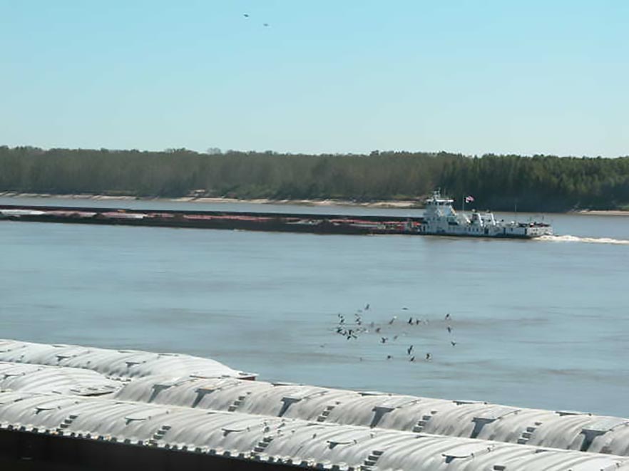
Figure 27. Barge at New Madrid, Missouri carries grain on the Mississippi River.
The St. Louis Iron Mountain was the first railroad built, starting about 1858 and completed in 1870. It extended from Bismarck, Missouri, in St. Francois County to Belmont, Missouri, (this town no longer exists) on the Mississippi River. The Missouri Pacific railroad between Cairo, Illinois, and Poplar Bluff, Missouri, was completed in 1867.
A rapid extension of railroads occurred after the Civil War. From 1880 to 1920, Louis Houck built 500 miles of railroad tracks networking the Delta region. Over time, small railroad companies in the United States merged and consolidated into seven major railways. Today, Burlington Northern Santa Fe Railway and the Union Pacific Railroad provide freight services in Southeast Missouri. New Orleans and Memphis are the principal markets for cotton, soybeans, oil, corn and wheat.
County, state, and interstate highways help farmers move harvested grain and fiber to markets. Interstate 55 and Interstate 57 cross the Delta region and provide truck routes to St. Louis, Memphis, Chicago and New Orleans.
Summary
Fertile soils, humid climate, level topography and abundant groundwater aquifers are important factors in crop production in the Delta region of Southeast Missouri. Furrow and center irrigation have been adopted by most farmers to reduce water stress from periods of low rainfall during the summer. If trends continue, farmers will adopt new technologies to increase crop yields and reduce input costs. Mechanization will decrease the demand for labor, which means larger farms with fewer growers.
Many Delta soils are classified somewhat poorly drained or poorly drained. Research should continue to develop crop varieties tolerant to waterlogging. Future development of the land must improve surface drainage, maintain soil organic matter and reduce cultivation. Managing fields to conserve crop residues and plant cover crops will improve soil structure and drainage.
Changes in cropping systems have occurred since the land was cleared, levees constructed, and ditches and channels made to prevent flooding. Conditions are favorable for growing many types of crops. This is most apparent in the phenomenal increase in rice and soybean acres. New crops and new varieties will be planted, and the intensification of agriculture will depend on careful soil management in the Delta region.
Note: This guide was originally published in 1966.