Phosphorus (P) is the nutrient limiting algal production in many Missouri streams and lakes. Water quality deteriorates when too much phosphorus enters a stream or lake, a process called eutrophication. Excess phosphorus also can reduce water clarity, cause fish kills, increase drinking water treatment costs and reduce the quality of drinking water.
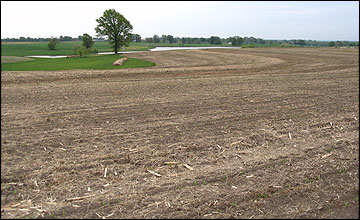 The phosphorus index promotes conservation practices that reduce phosphorus loss from agricultural fields.
Phosphorus loss from an agricultural field is determined by the interaction of many different characteristics of the field.
- Soil characteristics such as soil texture and soil depth affect the quantity of runoff from a field; more runoff can carry more phosphorus to a stream or lake.
- Soil type, soil cover and cropping practices affect the amount of soil loss from a field; more erosion carries more phosphorus to a stream or lake.
- Soil test phosphorus levels and the time elapsed between a surface application of manure or other phosphorus fertilizer and a runoff event affect the concentration of phosphorus in runoff; higher phosphorus concentrations in runoff carry more phosphorus to a stream or lake.
MU Extension publications G9181, Agricultural Phosphorus and Water Quality, and G9182, Managing Manure Phosphorus to Protect Water Quality, have additional information on the impact of excess phosphorus on stream and lake water quality and the factors affecting phosphorus loss from agricultural fields.
Government regulatory and cost-share programs require many farmers applying manure to assess the potential for phosphorus loss from their fields in an effort to reduce phosphorus loss from agricultural fields. For example, the U.S. Environmental Protection Agency (EPA) is implementing amended rules requiring permitted concentrated animal feeding operations to assess phosphorus loss on all fields receiving manure. The Natural Resources Conservation Service (NRCS) of the U.S. Department of Agriculture has similar requirements for any manure application on farms receiving incentives or cost-share funds through programs like the Environmental Quality Incentives Program (EQIP).
Background
A phosphorus index (P index) is one of the management tools that can be used to identify agricultural fields with a high potential for phosphorus losses in runoff. The P index is a systematic method for integrating a wide range of field characteristics into a prediction of the potential for phosphorus loss from the field. This integrated approach is needed because of the number and the complexity of the factors affecting phosphorus loss from agricultural fields; no single measurement or indicator is sufficient to predict phosphorus loss susceptibility of an agricultural field.
Each state has developed its own P index. Differences in climate, soil type, phosphorus soil testing method, crop management and sensitivity of receiving water all contribute to make locally developed P indexes more effective than a single national or regional approach. Phosphorus indexes also differ among states because there is legitimate debate concerning the most effective approach and strategy for designing and using a phosphorus index. Phosphorus indexes continue to evolve and improve because the P index is a relatively new concept.
The Missouri P index is designed to help identify fields that have a high probability of phosphorus loss from the combined effects of erosion and soil test phosphorus. It is designed to be used as part of developing a one- to five-year nutrient management plan. The Missouri P index integrates field information such as current soil test phosphorus level, expected presence or absence of tillage operations, anticipated land cover (based on crop and residue management), soil hydrologic category (a soil survey characteristic), and the distance of the field from a receiving body of water. The most complex parameter in the Missouri P index is the estimate of erosion derived from the NRCS erosion prediction software, RUSLE2 (RUSLE2 stands for Revised Universal Soil Loss Equation, version 2). The Missouri P index uses a simplified model approach to integrating the input information into a P index rating for a field. The Missouri P index is currently distributed as a Microsoft Excel spreadsheet available here: Phosphorus Index Worksheet (XLSX).
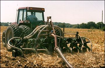 The phosphorus index is one of the tools used to develop a nutrient management plan.
Input data for the Missouri P index
This section details the specific requirements for all inputs in the Missouri P index spreadsheet.
County
Select the Missouri county from the drop-down list. The Missouri county must be entered for each field. The Missouri P index is not set up to work outside of Missouri.
Soil test P information
- Enter the numeric value for soil test P.
- Select the appropriate units from the drop-down list (pounds per acre or ppm).
- Select the extraction procedure used by the laboratory to determine soil test P from the drop-down list (Bray-I, Mehlich-III or water).
- Select the sampling depth used when obtaining the soil sample from the drop-down list (2 inches, 3 inches or 6 to 8 inches).
All the information except sampling depth should be on the soil test report you received from the soil testing laboratory. MU Soil and Plant Testing Laboratory reports soil test P in units of lb/acre and uses the Bray-I extraction procedure. Most agronomic soil samples are taken to a 6- to 8-inch depth.
Most agencies require the soil test data used in a P index be from samples taken less than three years prior to their use to evaluate phosphorus loss. A more recent sample may be required if phosphorus has been applied at rates that exceed crop removal since the last soil sample.
Avoid soil sampling a field soon after applying phosphorus. This would give artificially high results. It is best to wait at least three months after a phosphorus application to allow time for applied phosphorus to equilibrate with the soil.
Tillage
Select either "Tilled" or "No-till or forage" from the drop-down list. It is appropriate to select "Tilled" for any field that has had soil mixing in the past five years. The objective is to identify fields where lack of tillage has led to stratification, concentrating nutrients on the soil surface.
Erosion estimate from RUSLE2
Enter the RUSLE2 estimate of "average annual erosion loss" calculated for the cropping system for the field in the units of tons/acre/year. RUSLE2 is NRCS-supported software used to estimate erosion loss for a cropping sequence in a field. The erosion loss assessment includes the impact of soil type(s), crop cover, residue management and tillage activities. This analysis should be available for any field that has a completed NRCS conservation plan. Contact a local NRCS field office to see if they have RUSLE2 values for the field of interest.
Two points will help with using RUSLE2 with the Missouri P index. First, Missouri P index uses the dominant critical slope to estimate erosion losses within the field. The current P index does not account for the impact of conservation practices such as field borders and filter strips that reduce sediment delivery to water bodies.
Second, applying manure may require additional tillage activities potentially increasing erosion and the soil binding characteristics of the manure may potentially reduce erosion. The impact of these activities on erosion typically is not accounted for in the current Missouri P index. Many plans and planners have already run RUSLE2 before addressing manure management planning. Typically, we recommend using the existing RUSLE2 estimate of erosion for the Missouri P index. This approach avoids repeated runs of RUSLE2 and the Missouri P index as planners attempt to accommodate manure application scenarios on the RUSLE2 erosion estimates and the P index. For example, a hog operation plans on injecting manure into a cornfield that is also spring tilled before planting corn. The RUSLE2 estimate of erosion loss need not include the impact of the injection of manure on erosion loss in this tilled system. In another example, a farmer surface-applies poultry litter to a pasture. The RUSLE2 estimate of erosion loss need not include the effect of the surface application of litter on erosion loss from the pasture.
The erosion estimate from RUSLE2 should be rerun for a field when manure applications require tillage activities in systems characterized as no-till. For example, if a farmer plans on injecting manure every other year into soybean stubble in a system that otherwise has no tillage, then RUSLE2 should be rerun to account for the effect of the two tillage events introduced into a no-till system.
In the future, RUSLE2 will be more fully integrated into the nutrient management process and we will be able to better account for the effects of manure application on erosion loss.
Land cover
Select from a drop-down list of 20 possible land cover selections. These options integrate crop selection and conservation practices (e.g., small grain-contoured).
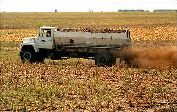 The phosphorus index is an example of a phosphorus loss assessment tool.
Hydrologic soil group and condition
- Select from a drop-down list (A, B, C or D) of the soil hydrologic groups. Soil hydrologic group is a characteristic of the soil and can be determined from the soil survey. This information is also available in the Missouri Animal Feeding Operation Site Assessment report available online at ims.missouri.edu/afosite.
- Select the soil hydrologic condition from a drop-down list (good, fair or poor). This judgment call evaluates the soil structure of the field. If the field is much more compacted than typical for this soil the hydrologic condition is poor. Soils with good soil structure are rated good.
Distance from center of field to water feature
Estimate the distance (in feet) from the approximate center of the field to the closest identified water feature or direct conduit to a water feature. Examples of water features include an intermittent stream, water impoundment and tile-line inlet left open during manure application.
Interpreting Missouri P index results
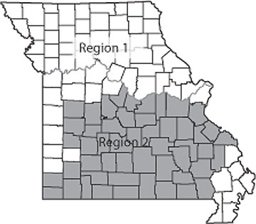 Figure 1
Delineation of Missouri regions for interpreting the P index. The assessment system is more restrictive in the Ozark region (Region 2).
The Missouri P index is used to assess the long-term potential for phosphorus from an agricultural field due to erosion and high soil test phosphorus. The Missouri P index calculates a value for a field and then converts that value into a phosphorus loss assessment rating of low, medium, high or very high. The interpretation of the four rating levels is as follows:
- Low
Nitrogen-based nutrient management allowed. - Medium
Nitrogen-based nutrient management allowed. Consider implementing phosphorus-based management of manure and other conservation practices to reduce phosphorus loss from the field. - High
Phosphorus-based manure management required. Additional land conservation practices to reduce phosphorus loss from this field highly recommended. - Very high
No manure applications recommended. Implement land conservation practices to reduce phosphorus loss from this field.
Nitrogen-based management implies that manure application rates can be determined annually based on the nitrogen need of the crop and the nitrogen content of the manure. For many types of manure, this strategy will result in significant increases in soil test phosphorus and an associated increase in potential phosphorus loss from the field. In some fields, raising soil test phosphorus is recommended to reverse the negative effect of low soil test phosphorus on crop yield and quality. In most fields, long-term use of nitrogen-based management will lead to a high phosphorus loss assessment rating. In other words, nitrogen-based management typically is not a long-term sustainable practice.
Phosphorus-based management is sustainable on a field. This strategy allows farmers to apply, in a single application, up to five years of phosphorus to a field to meet crop needs and then refrain from additional applications until the excess phosphorus has been removed by subsequent crops. This allows manure to be used as the sole source of nitrogen fertilizer in the year of manure application while typically providing multiple years of phosphorus fertilizer for crops.
The Missouri P index is more restrictive in the Ozark region of Missouri than in the rest of the state (see Figure 1). The Ozark region of Missouri has more restrictive interpretations because the water resource in that part of the state is more sensitive to phosphorus inputs. Table 1 details the ratings associated with specific P index values in each region of Missouri.
Table 1
The P index rating system as affected by region of Missouri.
| P index calculate value | ||
|---|---|---|
| P index rating | Region 1 | Region 2 |
| Low | =3 | =1 |
| Medium | >3 to =7 | >1 to =5 |
| High | >7 to =12 | >5 to =10 |
| Very high | >12 | >10 |
Finally, it is important to understand the mechanisms of phosphorus loss not addressed by the Missouri phosphorus index. The Missouri P index does not address leaching of phosphorus. Fields at most risk for leaching losses have sandy soils with very high soil test phosphorvus test levels. It also does not address phosphorus losses associated with rainfall events soon after surface applications of manure or other phosphorus fertilizers. These losses can be significant but are primarily driven by short-term weather factors that cannot be addressed in a long-term planning tool. Management practices to avoid manure application when runoff events are likely should be addressed in other parts of the nutrient management plan.
The Missouri P index is designed to be a phosphorus-loss assessment tool addressing phosphorus losses from erosion and soil test phosphorus in runoff from agricultural fields. The Missouri P index is specifically designed as a phosphorus loss assessment tool for use in developing a one- to five-year nutrient management plan for a farm. The ratings should be used to identify fields that have a high long-term potential for phosphorus in runoff and to identify fields that require additional conservation practices to reduce potential phosphorus loss in runoff.
Implementing the Missouri P index
The following examples show how the Missouri P index can be used as part of a nutrient management planning process.
Scenario 1
A farmer uses a cool-season hayfield for fall manure applications when weather conditions restrict access to row-crop fields earlier in the year. Agronomic soil testing indicated that this practice has led to a Bray-I soil test P level (0- to 6-inch sample) of 100 pounds per acre. MU soil test recommendation was that no fertilizer phosphorus be applied on this field. The soil test P level exceeds the amount needed to provide the phosphorus for crop production, and there is little probability of an increase in yield from any application of phosphorus.
The farmer wants to continue to use this field as a backup field for manure applications. The P index was used to evaluate the potential for phosphorus loss from this field that has elevated soil test P.
The field is in Pettis County, in Region 1. The average annual erosion loss is 1.3 tons/acre/year according to RUSLE2. The field is in hydrologic soil group C and is in good condition. The center of the field is approximately 300 feet from an intermittent stream.
Figure 2 shows P index data input and results for this field. The P index rating is "Medium," indicating that anticipated phosphorus losses from the field are low enough that use of the field for manure applications can continue.
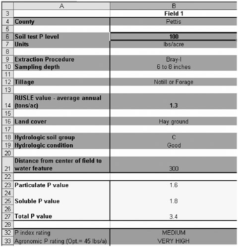 Figure 2
P index results for scenario 1.
Scenario 2
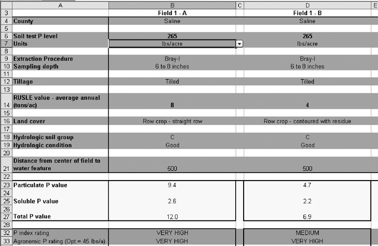
Figure 3
P index results for scenario 2 without (Field 1-A) or with (Field 1-B) soil conservation practices.
A farmer in Saline County (Region 1) has been using manure as a nitrogen fertilizer source for a field in a corn-soybean rotation. The field is tilled periodically with no soil conservation practices in place. Because of the repeated manure applications Bray-I soil test P level is 265 pounds per acre for a 0- to 6-inch sample.
With high fertilizer prices, the farmer wants to continue to use manure as the main nitrogen fertilizer for this field. The P index initially indicated a very high rating (Figure 3, Field 1-A). The nutrient management planner pointed out that erosion losses from the field were high because of the lack of conservation practices. The farmer agreed that planting on the contour and maintaining residue cover were important practices to conserve soil. These changes reduced estimated erosion to 4.5 tons/acre/year. The resulting P index rating was medium.
The nutrient management planner advised the farmer that the soil conservation practices would allow continued nitrogen-based applications on this field. However, this approach would lead to continued increases in soil test P and phosphorus limits on manure application in the near future. The nutrient management planner recommended transitioning to less frequent manure applications that did not exceed phosphorus removal capacity of the rotation before such practices were mandatory based on the P index.
Overview of calculations used in the Missouri P index
The Missouri P index combines values for particulate phosphorus and dissolved phosphorus in the following way:
| Missouri P index value | = [(soil test P (ppm) x 2.2 + native total P (ppm)) x (RUSLE2 erosion estimate (tons per acre per year)) |
| x sediment delivery ratio coefficient x particulate P availability factor] | |
| + [soil test P (ppm) x (soil test P vs. runoff P coefficient) | |
| x county runoff volume estimate x runoff curve number coefficient] |
Some notes on the current calculation of the Missouri P index:
- Soil test P is adjusted for sampling depth and tillage to reflect higher P concentrations in the surface soil layer of no-till and forages (calculation not shown).
- Soil test P multiplied by a factor (2.2) to estimate total P applied to raise soil test P to that value.
- Biological availability of particulate P in surface water is currently set at 0.75.
- Runoff volume calculated on county-by-county long-term average rainfall. An approach based on curve number adjusts runoff volume for specific soil cover.